You are here: Home > Network List > GT - Global Telemetered Seismograph Network (USAF/USGS) Stations List
> Station LPAZ La Paz , Bolivia > Earthquake Result Viewer
LPAZ La Paz , Bolivia - Earthquake Result Viewer

| Earthquake location: |
South Sandwich Islands Region |
| Earthquake latitude/longitude: |
-56.9/-25.7 |
| Earthquake time(UTC): |
2021/08/16 (228) 05:46:18 GMT |
| Earthquake Depth: |
16 km |
| Earthquake Magnitude: |
5.7 Mww |
| Earthquake Catalog/Contributor: |
NEIC PDE/us |
|
| Network: |
GT Global Telemetered Seismograph Network (USAF/USGS) |
| Station: |
LPAZ La Paz , Bolivia |
| Lat/Lon: |
16.17 S/68.08 W |
| Elevation: |
4817 m |
|
| Distance: |
51.6 deg |
| Az: |
304.252 deg |
| Baz: |
151.838 deg |
| Ray Param: |
0.06727679 |
| Estimated Moho Depth: |
26.75 km |
| Estimated Crust Vp/Vs: |
1.62 |
| Assumed Crust Vp: |
6.454 km/s |
| Estimated Crust Vs: |
3.996 km/s |
| Estimated Crust Poisson's Ratio: |
0.19 |
|
| Radial Match: |
85.96137 % |
| Radial Bump: |
400 |
| Transverse Match: |
87.944 % |
| Transverse Bump: |
400 |
| SOD ConfigId: |
25131211 |
| Insert Time: |
2021-08-30 05:49:06.465 +0000 |
| GWidth: |
2.5 |
| Max Bumps: |
400 |
| Tol: |
0.001 |
|
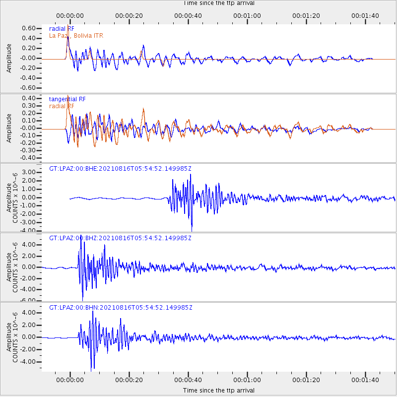
Signal To Noise
| Channel | StoN | STA | LTA |
| GT:LPAZ:00:BHZ:20210816T05:54:52.149985Z | 19.30623 | 1.9641175E-6 | 1.01734905E-7 |
| GT:LPAZ:00:BHN:20210816T05:54:52.149985Z | 9.220589 | 6.3503205E-7 | 6.8871095E-8 |
| GT:LPAZ:00:BHE:20210816T05:54:52.149985Z | 9.941715 | 6.3201554E-7 | 6.357208E-8 |
| Arrivals |
| Ps | 2.7 SECOND |
| PpPs | 10 SECOND |
| PsPs/PpSs | 13 SECOND |


