You are here: Home > Network List > CM - Red Sismologica Nacional de Columbia Stations List
> Station SMAR Santa Marta, Magdalena, Colombia > Earthquake Result Viewer
SMAR Santa Marta, Magdalena, Colombia - Earthquake Result Viewer
| Earthquake location: |
South Sandwich Islands Region |
| Earthquake latitude/longitude: |
-58.4/-23.3 |
| Earthquake time(UTC): |
2021/08/16 (228) 11:10:35 GMT |
| Earthquake Depth: |
10 km |
| Earthquake Magnitude: |
6.9 Mww |
| Earthquake Catalog/Contributor: |
NEIC PDE/us |
|
| Network: |
CM Red Sismologica Nacional de Columbia |
| Station: |
SMAR Santa Marta, Magdalena, Colombia |
| Lat/Lon: |
11.16 N/74.22 W |
| Elevation: |
122 m |
|
| Distance: |
80.6 deg |
| Az: |
309.489 deg |
| Baz: |
155.524 deg |
| Ray Param: |
0.04813956 |
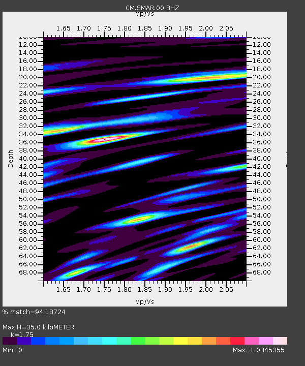
| Estimated Moho Depth: |
35.0 km |
| Estimated Crust Vp/Vs: |
1.75 |
| Assumed Crust Vp: |
5.129 km/s |
| Estimated Crust Vs: |
2.931 km/s |
| Estimated Crust Poisson's Ratio: |
0.26 |
|
| Radial Match: |
94.18724 % |
| Radial Bump: |
400 |
| Transverse Match: |
87.07474 % |
| Transverse Bump: |
400 |
| SOD ConfigId: |
25131211 |
| Insert Time: |
2021-08-30 11:13:28.031 +0000 |
| GWidth: |
2.5 |
| Max Bumps: |
400 |
| Tol: |
0.001 |
|

Signal To Noise
| Channel | StoN | STA | LTA |
| CM:SMAR:00:BHZ:20210816T11:22:17.169008Z | 33.55505 | 1.7307694E-6 | 5.158E-8 |
| CM:SMAR:00:BHN:20210816T11:22:17.169008Z | 18.652733 | 7.8261434E-7 | 4.1957087E-8 |
| CM:SMAR:00:BHE:20210816T11:22:17.169008Z | 7.9232454 | 3.8130278E-7 | 4.8124573E-8 |
| Arrivals |
| Ps | 5.2 SECOND |
| PpPs | 18 SECOND |
| PsPs/PpSs | 24 SECOND |


