You are here: Home > Network List > G - GEOSCOPE Stations List
> Station TAM Tamanrasset, Algeria > Earthquake Result Viewer
TAM Tamanrasset, Algeria - Earthquake Result Viewer
| Earthquake location: |
South Sandwich Islands Region |
| Earthquake latitude/longitude: |
-58.4/-23.3 |
| Earthquake time(UTC): |
2021/08/16 (228) 11:10:35 GMT |
| Earthquake Depth: |
10 km |
| Earthquake Magnitude: |
6.9 Mww |
| Earthquake Catalog/Contributor: |
NEIC PDE/us |
|
| Network: |
G GEOSCOPE |
| Station: |
TAM Tamanrasset, Algeria |
| Lat/Lon: |
22.79 N/5.53 E |
| Elevation: |
1377 m |
|
| Distance: |
84.4 deg |
| Az: |
26.589 deg |
| Baz: |
194.804 deg |
| Ray Param: |
0.045546312 |
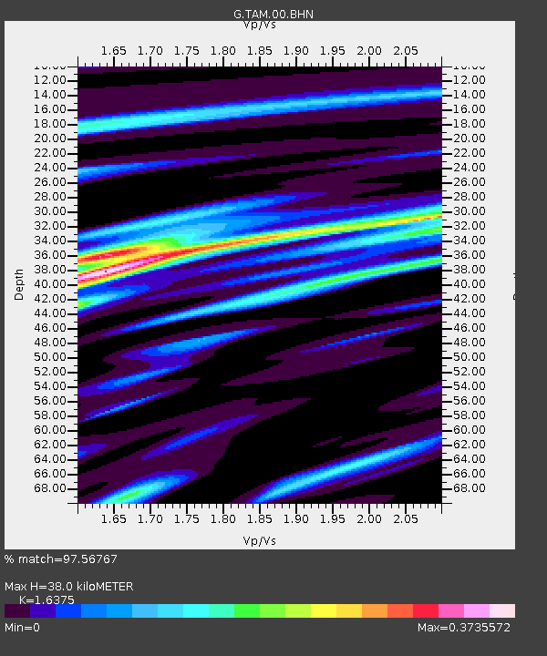
| Estimated Moho Depth: |
38.0 km |
| Estimated Crust Vp/Vs: |
1.64 |
| Assumed Crust Vp: |
6.61 km/s |
| Estimated Crust Vs: |
4.037 km/s |
| Estimated Crust Poisson's Ratio: |
0.20 |
|
| Radial Match: |
97.56767 % |
| Radial Bump: |
248 |
| Transverse Match: |
52.468235 % |
| Transverse Bump: |
400 |
| SOD ConfigId: |
25131211 |
| Insert Time: |
2021-08-30 11:14:22.282 +0000 |
| GWidth: |
2.5 |
| Max Bumps: |
400 |
| Tol: |
0.001 |
|
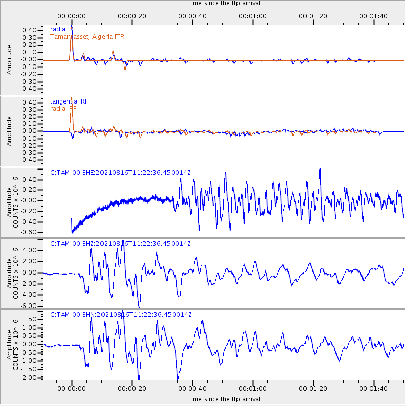
Signal To Noise
| Channel | StoN | STA | LTA |
| G:TAM:00:BHZ:20210816T11:22:36.450014Z | 18.223923 | 1.1799051E-6 | 6.4744846E-8 |
| G:TAM:00:BHN:20210816T11:22:36.450014Z | 7.957851 | 4.1128462E-7 | 5.1682875E-8 |
| G:TAM:00:BHE:20210816T11:22:36.450014Z | 0.855418 | 1.5645253E-7 | 1.8289597E-7 |
| Arrivals |
| Ps | 3.8 SECOND |
| PpPs | 15 SECOND |
| PsPs/PpSs | 19 SECOND |


