You are here: Home > Network List > GT - Global Telemetered Seismograph Network (USAF/USGS) Stations List
> Station BOSA Boshof, South Africa > Earthquake Result Viewer
BOSA Boshof, South Africa - Earthquake Result Viewer
| Earthquake location: |
South Sandwich Islands Region |
| Earthquake latitude/longitude: |
-58.4/-23.3 |
| Earthquake time(UTC): |
2021/08/16 (228) 11:10:35 GMT |
| Earthquake Depth: |
10 km |
| Earthquake Magnitude: |
6.9 Mww |
| Earthquake Catalog/Contributor: |
NEIC PDE/us |
|
| Network: |
GT Global Telemetered Seismograph Network (USAF/USGS) |
| Station: |
BOSA Boshof, South Africa |
| Lat/Lon: |
28.61 S/25.26 E |
| Elevation: |
1280 m |
|
| Distance: |
44.7 deg |
| Az: |
69.744 deg |
| Baz: |
214.204 deg |
| Ray Param: |
0.071793385 |
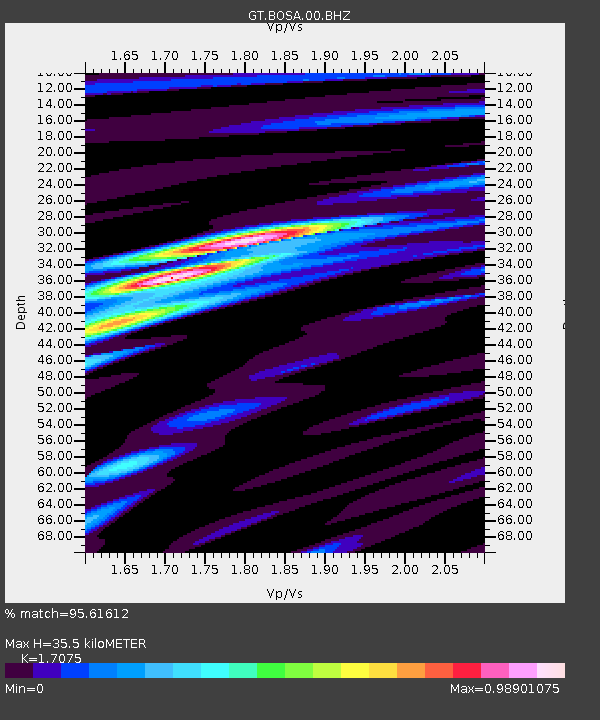
| Estimated Moho Depth: |
35.5 km |
| Estimated Crust Vp/Vs: |
1.71 |
| Assumed Crust Vp: |
6.459 km/s |
| Estimated Crust Vs: |
3.783 km/s |
| Estimated Crust Poisson's Ratio: |
0.24 |
|
| Radial Match: |
95.61612 % |
| Radial Bump: |
281 |
| Transverse Match: |
83.917984 % |
| Transverse Bump: |
400 |
| SOD ConfigId: |
25131211 |
| Insert Time: |
2021-08-30 11:14:35.220 +0000 |
| GWidth: |
2.5 |
| Max Bumps: |
400 |
| Tol: |
0.001 |
|
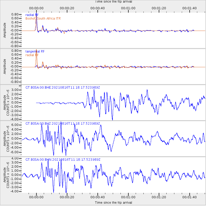
Signal To Noise
| Channel | StoN | STA | LTA |
| GT:BOSA:00:BHZ:20210816T11:18:17.523989Z | 8.10281 | 2.2339539E-6 | 2.7570113E-7 |
| GT:BOSA:00:BHN:20210816T11:18:17.523989Z | 4.776151 | 1.06333E-6 | 2.2263325E-7 |
| GT:BOSA:00:BHE:20210816T11:18:17.523989Z | 11.222991 | 1.026959E-6 | 9.150493E-8 |
| Arrivals |
| Ps | 4.2 SECOND |
| PpPs | 14 SECOND |
| PsPs/PpSs | 18 SECOND |


