You are here: Home > Network List > WI - West Indies IPGP Network Stations List
> Station BIM Morne Bigot, Anses d'Arlets, Martinique > Earthquake Result Viewer
BIM Morne Bigot, Anses d'Arlets, Martinique - Earthquake Result Viewer

| Earthquake location: |
South Sandwich Islands Region |
| Earthquake latitude/longitude: |
-58.4/-23.3 |
| Earthquake time(UTC): |
2021/08/16 (228) 11:10:35 GMT |
| Earthquake Depth: |
10 km |
| Earthquake Magnitude: |
6.9 Mww |
| Earthquake Catalog/Contributor: |
NEIC PDE/us |
|
| Network: |
WI West Indies IPGP Network |
| Station: |
BIM Morne Bigot, Anses d'Arlets, Martinique |
| Lat/Lon: |
14.52 N/61.07 W |
| Elevation: |
391 m |
|
| Distance: |
78.9 deg |
| Az: |
322.849 deg |
| Baz: |
160.822 deg |
| Ray Param: |
0.049300186 |
| Estimated Moho Depth: |
57.75 km |
| Estimated Crust Vp/Vs: |
1.92 |
| Assumed Crust Vp: |
5.88 km/s |
| Estimated Crust Vs: |
3.059 km/s |
| Estimated Crust Poisson's Ratio: |
0.31 |
|
| Radial Match: |
87.074066 % |
| Radial Bump: |
400 |
| Transverse Match: |
88.37582 % |
| Transverse Bump: |
400 |
| SOD ConfigId: |
25131211 |
| Insert Time: |
2021-08-30 11:17:15.602 +0000 |
| GWidth: |
2.5 |
| Max Bumps: |
400 |
| Tol: |
0.001 |
|
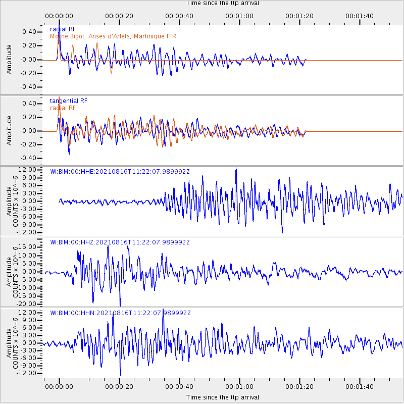
Signal To Noise
| Channel | StoN | STA | LTA |
| WI:BIM:00:HHZ:20210816T11:22:07.989992Z | 5.7784634 | 2.0927357E-6 | 3.621613E-7 |
| WI:BIM:00:HHN:20210816T11:22:07.989992Z | 1.9387163 | 9.553089E-7 | 4.927533E-7 |
| WI:BIM:00:HHE:20210816T11:22:07.989992Z | 1.3607541 | 6.535546E-7 | 4.802885E-7 |
| Arrivals |
| Ps | 9.3 SECOND |
| PpPs | 28 SECOND |
| PsPs/PpSs | 37 SECOND |


