You are here: Home > Network List > AV - Alaska Volcano Observatory Stations List
> Station PLBL Mt. Peulik Volcano, Alaska > Earthquake Result Viewer
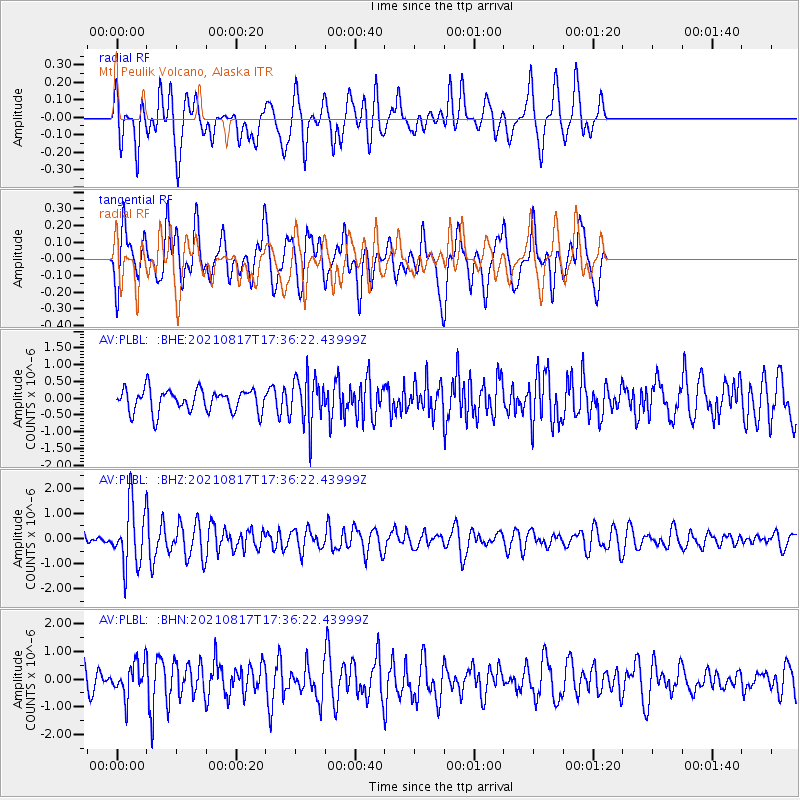
PLBL Mt. Peulik Volcano, Alaska - Earthquake Result Viewer
*The percent match for this event was below the threshold and hence no stack was calculated.
| Earthquake location: |
South Of Fiji Islands |
| Earthquake latitude/longitude: |
-23.2/-177.0 |
| Earthquake time(UTC): |
2021/08/17 (229) 17:24:47 GMT |
| Earthquake Depth: |
139 km |
| Earthquake Magnitude: |
5.8 Mww |
| Earthquake Catalog/Contributor: |
NEIC PDE/us |
|
| Network: |
AV Alaska Volcano Observatory |
| Station: |
PLBL Mt. Peulik Volcano, Alaska |
| Lat/Lon: |
57.70 N/156.82 W |
| Elevation: |
461 m |
|
| Distance: |
82.4 deg |
| Az: |
10.748 deg |
| Baz: |
198.635 deg |
| Ray Param: |
$rayparam |
*The percent match for this event was below the threshold and hence was not used in the summary stack. |
|
| Radial Match: |
49.71644 % |
| Radial Bump: |
348 |
| Transverse Match: |
61.41783 % |
| Transverse Bump: |
400 |
| SOD ConfigId: |
25131211 |
| Insert Time: |
2021-08-31 17:31:49.532 +0000 |
| GWidth: |
2.5 |
| Max Bumps: |
400 |
| Tol: |
0.001 |
|
Signal To Noise
| Channel | StoN | STA | LTA |
| AV:PLBL: :BHZ:20210817T17:36:22.43999Z | 6.9723706 | 1.1870112E-6 | 1.7024499E-7 |
| AV:PLBL: :BHN:20210817T17:36:22.43999Z | 1.3212004 | 5.913126E-7 | 4.4755708E-7 |
| AV:PLBL: :BHE:20210817T17:36:22.43999Z | 2.1494164 | 7.2074334E-7 | 3.3532046E-7 |
| Arrivals |
| Ps | |
| PpPs | |
| PsPs/PpSs | |


