You are here: Home > Network List > C8 - Canadian Seismic Research Network () Stations List
> Station GRIB Gribbell Island, BC, CA > Earthquake Result Viewer
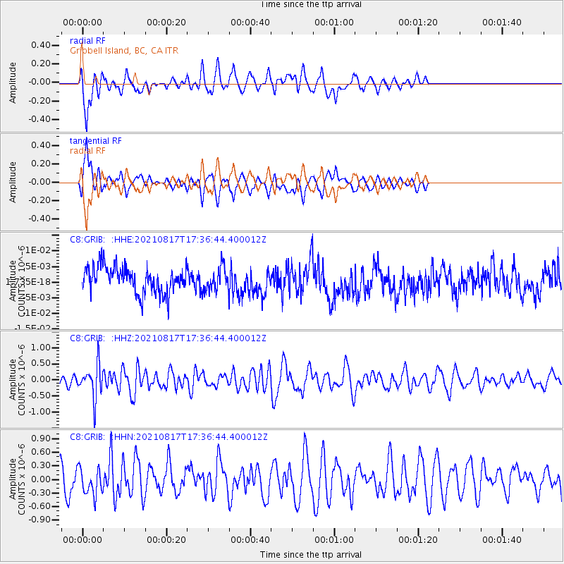
GRIB Gribbell Island, BC, CA - Earthquake Result Viewer
*The percent match for this event was below the threshold and hence no stack was calculated.
| Earthquake location: |
South Of Fiji Islands |
| Earthquake latitude/longitude: |
-23.2/-177.0 |
| Earthquake time(UTC): |
2021/08/17 (229) 17:24:47 GMT |
| Earthquake Depth: |
139 km |
| Earthquake Magnitude: |
5.8 Mww |
| Earthquake Catalog/Contributor: |
NEIC PDE/us |
|
| Network: |
C8 Canadian Seismic Research Network () |
| Station: |
GRIB Gribbell Island, BC, CA |
| Lat/Lon: |
53.34 N/129.14 W |
| Elevation: |
418 m |
|
| Distance: |
86.7 deg |
| Az: |
26.428 deg |
| Baz: |
223.064 deg |
| Ray Param: |
$rayparam |
*The percent match for this event was below the threshold and hence was not used in the summary stack. |
|
| Radial Match: |
58.72145 % |
| Radial Bump: |
400 |
| Transverse Match: |
58.736763 % |
| Transverse Bump: |
400 |
| SOD ConfigId: |
25131211 |
| Insert Time: |
2021-08-31 17:34:04.177 +0000 |
| GWidth: |
2.5 |
| Max Bumps: |
400 |
| Tol: |
0.001 |
|
Signal To Noise
| Channel | StoN | STA | LTA |
| C8:GRIB: :HHZ:20210817T17:36:44.400012Z | 3.1961508 | 5.2573694E-7 | 1.6449064E-7 |
| C8:GRIB: :HHN:20210817T17:36:44.400012Z | 0.95547646 | 2.9798636E-7 | 3.11872E-7 |
| C8:GRIB: :HHE:20210817T17:36:44.400012Z | 0.8711123 | 3.6074792E-9 | 4.1412336E-9 |
| Arrivals |
| Ps | |
| PpPs | |
| PsPs/PpSs | |


