You are here: Home > Network List > CN - Canadian National Seismograph Network Stations List
> Station INK INUVIK, NT > Earthquake Result Viewer
INK INUVIK, NT - Earthquake Result Viewer
*The percent match for this event was below the threshold and hence no stack was calculated.
| Earthquake location: |
South Of Fiji Islands |
| Earthquake latitude/longitude: |
-23.2/-177.0 |
| Earthquake time(UTC): |
2021/08/17 (229) 17:24:47 GMT |
| Earthquake Depth: |
139 km |
| Earthquake Magnitude: |
5.8 Mww |
| Earthquake Catalog/Contributor: |
NEIC PDE/us |
|
| Network: |
CN Canadian National Seismograph Network |
| Station: |
INK INUVIK, NT |
| Lat/Lon: |
68.31 N/133.53 W |
| Elevation: |
44 m |
|
| Distance: |
96.6 deg |
| Az: |
14.911 deg |
| Baz: |
219.548 deg |
| Ray Param: |
$rayparam |
*The percent match for this event was below the threshold and hence was not used in the summary stack. |
|
| Radial Match: |
50.653797 % |
| Radial Bump: |
400 |
| Transverse Match: |
57.27412 % |
| Transverse Bump: |
400 |
| SOD ConfigId: |
25131211 |
| Insert Time: |
2021-08-31 17:36:39.477 +0000 |
| GWidth: |
2.5 |
| Max Bumps: |
400 |
| Tol: |
0.001 |
|
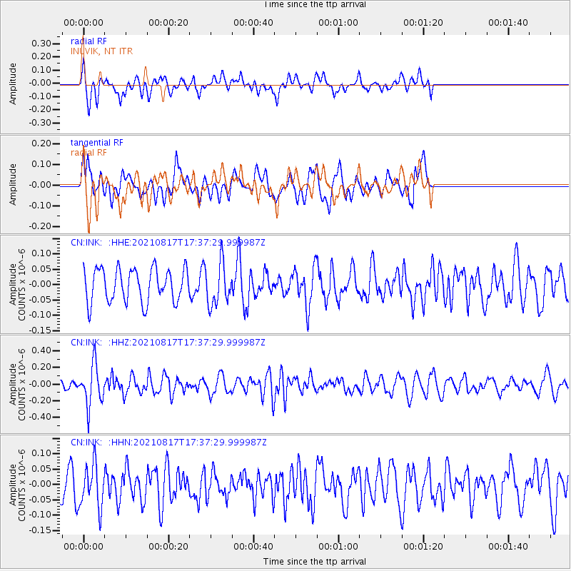
Signal To Noise
| Channel | StoN | STA | LTA |
| CN:INK: :HHZ:20210817T17:37:29.999987Z | 4.117529 | 2.510176E-7 | 6.096317E-8 |
| CN:INK: :HHN:20210817T17:37:29.999987Z | 1.3413212 | 7.00744E-8 | 5.2242818E-8 |
| CN:INK: :HHE:20210817T17:37:29.999987Z | 1.2803718 | 6.89672E-8 | 5.3864984E-8 |
| Arrivals |
| Ps | |
| PpPs | |
| PsPs/PpSs | |


