You are here: Home > Network List > US - United States National Seismic Network Stations List
> Station HAWA Hanford, Washington, USA > Earthquake Result Viewer
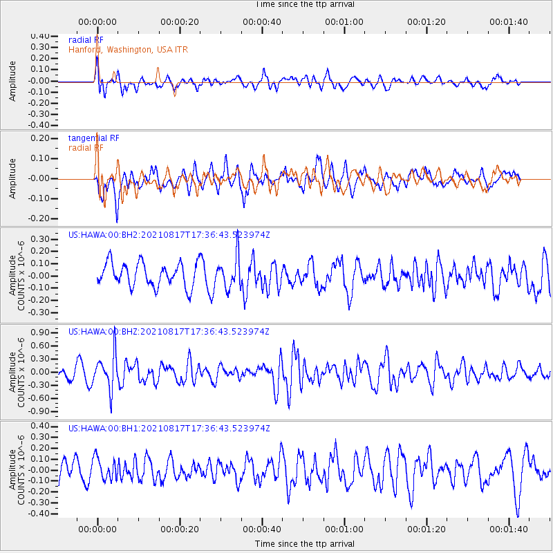
HAWA Hanford, Washington, USA - Earthquake Result Viewer
*The percent match for this event was below the threshold and hence no stack was calculated.
| Earthquake location: |
South Of Fiji Islands |
| Earthquake latitude/longitude: |
-23.2/-177.0 |
| Earthquake time(UTC): |
2021/08/17 (229) 17:24:47 GMT |
| Earthquake Depth: |
139 km |
| Earthquake Magnitude: |
5.8 Mww |
| Earthquake Catalog/Contributor: |
NEIC PDE/us |
|
| Network: |
US United States National Seismic Network |
| Station: |
HAWA Hanford, Washington, USA |
| Lat/Lon: |
46.39 N/119.53 W |
| Elevation: |
364 m |
|
| Distance: |
86.6 deg |
| Az: |
35.753 deg |
| Baz: |
230.953 deg |
| Ray Param: |
$rayparam |
*The percent match for this event was below the threshold and hence was not used in the summary stack. |
|
| Radial Match: |
59.52383 % |
| Radial Bump: |
400 |
| Transverse Match: |
67.46603 % |
| Transverse Bump: |
400 |
| SOD ConfigId: |
25131211 |
| Insert Time: |
2021-08-31 17:46:14.061 +0000 |
| GWidth: |
2.5 |
| Max Bumps: |
400 |
| Tol: |
0.001 |
|
Signal To Noise
| Channel | StoN | STA | LTA |
| US:HAWA:00:BHZ:20210817T17:36:43.523974Z | 2.3872721 | 4.0188297E-7 | 1.6834402E-7 |
| US:HAWA:00:BH1:20210817T17:36:43.523974Z | 1.2296034 | 9.869863E-8 | 8.026867E-8 |
| US:HAWA:00:BH2:20210817T17:36:43.523974Z | 1.369029 | 1.3071636E-7 | 9.548108E-8 |
| Arrivals |
| Ps | |
| PpPs | |
| PsPs/PpSs | |


