You are here: Home > Network List > UU - University of Utah Regional Network Stations List
> Station CCUT Cedar City, UT, USA > Earthquake Result Viewer
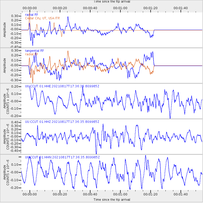
CCUT Cedar City, UT, USA - Earthquake Result Viewer
*The percent match for this event was below the threshold and hence no stack was calculated.
| Earthquake location: |
South Of Fiji Islands |
| Earthquake latitude/longitude: |
-23.2/-177.0 |
| Earthquake time(UTC): |
2021/08/17 (229) 17:24:47 GMT |
| Earthquake Depth: |
139 km |
| Earthquake Magnitude: |
5.8 Mww |
| Earthquake Catalog/Contributor: |
NEIC PDE/us |
|
| Network: |
UU University of Utah Regional Network |
| Station: |
CCUT Cedar City, UT, USA |
| Lat/Lon: |
37.55 N/113.36 W |
| Elevation: |
2127 m |
|
| Distance: |
85.0 deg |
| Az: |
45.609 deg |
| Baz: |
235.806 deg |
| Ray Param: |
$rayparam |
*The percent match for this event was below the threshold and hence was not used in the summary stack. |
|
| Radial Match: |
56.74733 % |
| Radial Bump: |
400 |
| Transverse Match: |
58.887337 % |
| Transverse Bump: |
400 |
| SOD ConfigId: |
25131211 |
| Insert Time: |
2021-08-31 17:46:35.441 +0000 |
| GWidth: |
2.5 |
| Max Bumps: |
400 |
| Tol: |
0.001 |
|
Signal To Noise
| Channel | StoN | STA | LTA |
| UU:CCUT:01:HHZ:20210817T17:36:35.809985Z | 0.9512985 | 8.758379E-8 | 9.206762E-8 |
| UU:CCUT:01:HHN:20210817T17:36:35.809985Z | 1.2162659 | 1.5150353E-7 | 1.2456448E-7 |
| UU:CCUT:01:HHE:20210817T17:36:35.809985Z | 1.1801416 | 9.709284E-8 | 8.2272194E-8 |
| Arrivals |
| Ps | |
| PpPs | |
| PsPs/PpSs | |


