You are here: Home > Network List > WI - West Indies IPGP Network Stations List
> Station BIM Morne Bigot, Anses d'Arlets, Martinique > Earthquake Result Viewer
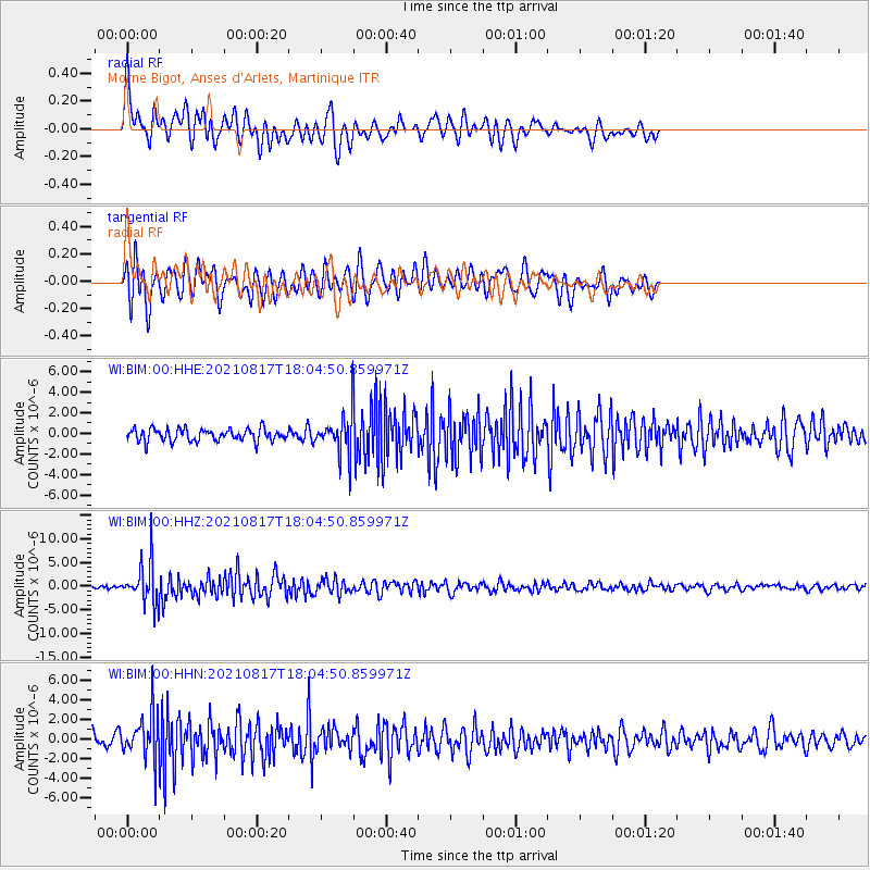
BIM Morne Bigot, Anses d'Arlets, Martinique - Earthquake Result Viewer
*The percent match for this event was below the threshold and hence no stack was calculated.
| Earthquake location: |
South Sandwich Islands Region |
| Earthquake latitude/longitude: |
-58.0/-25.4 |
| Earthquake time(UTC): |
2021/08/17 (229) 17:53:26 GMT |
| Earthquake Depth: |
32 km |
| Earthquake Magnitude: |
6.1 mww |
| Earthquake Catalog/Contributor: |
NEIC PDE/us |
|
| Network: |
WI West Indies IPGP Network |
| Station: |
BIM Morne Bigot, Anses d'Arlets, Martinique |
| Lat/Lon: |
14.52 N/61.07 W |
| Elevation: |
391 m |
|
| Distance: |
78.0 deg |
| Az: |
324.767 deg |
| Baz: |
161.532 deg |
| Ray Param: |
$rayparam |
*The percent match for this event was below the threshold and hence was not used in the summary stack. |
|
| Radial Match: |
66.86445 % |
| Radial Bump: |
400 |
| Transverse Match: |
75.68204 % |
| Transverse Bump: |
400 |
| SOD ConfigId: |
25131211 |
| Insert Time: |
2021-08-31 17:59:11.955 +0000 |
| GWidth: |
2.5 |
| Max Bumps: |
400 |
| Tol: |
0.001 |
|
Signal To Noise
| Channel | StoN | STA | LTA |
| WI:BIM:00:HHZ:20210817T18:04:50.859971Z | 13.2635765 | 4.3641203E-6 | 3.2903043E-7 |
| WI:BIM:00:HHN:20210817T18:04:50.859971Z | 3.9118562 | 2.3833666E-6 | 6.092675E-7 |
| WI:BIM:00:HHE:20210817T18:04:50.859971Z | 3.027623 | 1.8144198E-6 | 5.9928857E-7 |
| Arrivals |
| Ps | |
| PpPs | |
| PsPs/PpSs | |


