You are here: Home > Network List > AK - Alaska Regional Network Stations List
> Station BAE Barry Arm East, AK, USA > Earthquake Result Viewer
BAE Barry Arm East, AK, USA - Earthquake Result Viewer
| Earthquake location: |
Vanuatu Islands |
| Earthquake latitude/longitude: |
-14.9/167.1 |
| Earthquake time(UTC): |
2021/08/18 (230) 10:10:05 GMT |
| Earthquake Depth: |
91 km |
| Earthquake Magnitude: |
6.8 mww |
| Earthquake Catalog/Contributor: |
NEIC PDE/us |
|
| Network: |
AK Alaska Regional Network |
| Station: |
BAE Barry Arm East, AK, USA |
| Lat/Lon: |
61.13 N/148.12 W |
| Elevation: |
578 m |
|
| Distance: |
83.7 deg |
| Az: |
20.119 deg |
| Baz: |
223.259 deg |
| Ray Param: |
0.045805983 |
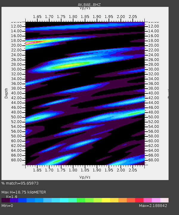
| Estimated Moho Depth: |
18.75 km |
| Estimated Crust Vp/Vs: |
1.60 |
| Assumed Crust Vp: |
6.566 km/s |
| Estimated Crust Vs: |
4.104 km/s |
| Estimated Crust Poisson's Ratio: |
0.18 |
|
| Radial Match: |
85.65973 % |
| Radial Bump: |
400 |
| Transverse Match: |
73.31628 % |
| Transverse Bump: |
400 |
| SOD ConfigId: |
25131211 |
| Insert Time: |
2021-09-01 10:11:05.755 +0000 |
| GWidth: |
2.5 |
| Max Bumps: |
400 |
| Tol: |
0.001 |
|

Signal To Noise
| Channel | StoN | STA | LTA |
| AK:BAE: :BHZ:20210818T10:21:52.708011Z | 10.169446 | 2.606114E-6 | 2.5626906E-7 |
| AK:BAE: :BHN:20210818T10:21:52.708011Z | 3.6396658 | 7.4267376E-7 | 2.0405E-7 |
| AK:BAE: :BHE:20210818T10:21:52.708011Z | 2.2744186 | 8.26188E-7 | 3.6325238E-7 |
| Arrivals |
| Ps | 1.8 SECOND |
| PpPs | 7.2 SECOND |
| PsPs/PpSs | 9.0 SECOND |


