You are here: Home > Network List > AK - Alaska Regional Network Stations List
> Station J17K VABM Dome, AK, USA > Earthquake Result Viewer
J17K VABM Dome, AK, USA - Earthquake Result Viewer
| Earthquake location: |
Vanuatu Islands |
| Earthquake latitude/longitude: |
-14.9/167.1 |
| Earthquake time(UTC): |
2021/08/18 (230) 10:10:05 GMT |
| Earthquake Depth: |
91 km |
| Earthquake Magnitude: |
6.8 mww |
| Earthquake Catalog/Contributor: |
NEIC PDE/us |
|
| Network: |
AK Alaska Regional Network |
| Station: |
J17K VABM Dome, AK, USA |
| Lat/Lon: |
63.40 N/159.08 W |
| Elevation: |
323 m |
|
| Distance: |
82.3 deg |
| Az: |
14.653 deg |
| Baz: |
212.904 deg |
| Ray Param: |
0.046775796 |
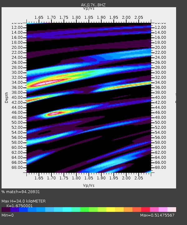
| Estimated Moho Depth: |
34.0 km |
| Estimated Crust Vp/Vs: |
1.68 |
| Assumed Crust Vp: |
6.276 km/s |
| Estimated Crust Vs: |
3.747 km/s |
| Estimated Crust Poisson's Ratio: |
0.22 |
|
| Radial Match: |
94.28931 % |
| Radial Bump: |
400 |
| Transverse Match: |
78.581535 % |
| Transverse Bump: |
400 |
| SOD ConfigId: |
25131211 |
| Insert Time: |
2021-09-01 10:12:56.469 +0000 |
| GWidth: |
2.5 |
| Max Bumps: |
400 |
| Tol: |
0.001 |
|

Signal To Noise
| Channel | StoN | STA | LTA |
| AK:J17K: :BHZ:20210818T10:21:45.640018Z | 42.2685 | 3.3798806E-6 | 7.9962156E-8 |
| AK:J17K: :BHN:20210818T10:21:45.640018Z | 9.157608 | 9.540527E-7 | 1.04181424E-7 |
| AK:J17K: :BHE:20210818T10:21:45.640018Z | 9.825573 | 7.5390466E-7 | 7.6728824E-8 |
| Arrivals |
| Ps | 3.8 SECOND |
| PpPs | 14 SECOND |
| PsPs/PpSs | 18 SECOND |


