You are here: Home > Network List > AV - Alaska Volcano Observatory Stations List
> Station CEAP Anvil Peak, Cerberus Volcano, Alaska > Earthquake Result Viewer
CEAP Anvil Peak, Cerberus Volcano, Alaska - Earthquake Result Viewer
| Earthquake location: |
Vanuatu Islands |
| Earthquake latitude/longitude: |
-14.9/167.1 |
| Earthquake time(UTC): |
2021/08/18 (230) 10:10:05 GMT |
| Earthquake Depth: |
91 km |
| Earthquake Magnitude: |
6.8 mww |
| Earthquake Catalog/Contributor: |
NEIC PDE/us |
|
| Network: |
AV Alaska Volcano Observatory |
| Station: |
CEAP Anvil Peak, Cerberus Volcano, Alaska |
| Lat/Lon: |
52.00 N/179.58 E |
| Elevation: |
244 m |
|
| Distance: |
67.5 deg |
| Az: |
8.322 deg |
| Baz: |
193.082 deg |
| Ray Param: |
0.056702107 |
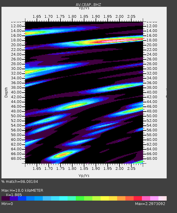
| Estimated Moho Depth: |
18.0 km |
| Estimated Crust Vp/Vs: |
1.99 |
| Assumed Crust Vp: |
6.183 km/s |
| Estimated Crust Vs: |
3.115 km/s |
| Estimated Crust Poisson's Ratio: |
0.33 |
|
| Radial Match: |
86.08184 % |
| Radial Bump: |
400 |
| Transverse Match: |
76.578156 % |
| Transverse Bump: |
400 |
| SOD ConfigId: |
25131211 |
| Insert Time: |
2021-09-01 10:16:32.297 +0000 |
| GWidth: |
2.5 |
| Max Bumps: |
400 |
| Tol: |
0.001 |
|
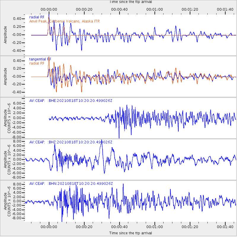
Signal To Noise
| Channel | StoN | STA | LTA |
| AV:CEAP: :BHZ:20210818T10:20:20.499026Z | 10.301982 | 3.2029438E-6 | 3.1090556E-7 |
| AV:CEAP: :BHN:20210818T10:20:20.499026Z | 3.2065732 | 1.2542143E-6 | 3.911385E-7 |
| AV:CEAP: :BHE:20210818T10:20:20.499026Z | 2.6921432 | 9.551496E-7 | 3.5479152E-7 |
| Arrivals |
| Ps | 3.0 SECOND |
| PpPs | 8.4 SECOND |
| PsPs/PpSs | 11 SECOND |


