You are here: Home > Network List > AV - Alaska Volcano Observatory Stations List
> Station GSTR Teapot Rock, Great Sitkin Volcano, Alaska > Earthquake Result Viewer
GSTR Teapot Rock, Great Sitkin Volcano, Alaska - Earthquake Result Viewer
| Earthquake location: |
Vanuatu Islands |
| Earthquake latitude/longitude: |
-14.9/167.1 |
| Earthquake time(UTC): |
2021/08/18 (230) 10:10:05 GMT |
| Earthquake Depth: |
91 km |
| Earthquake Magnitude: |
6.8 mww |
| Earthquake Catalog/Contributor: |
NEIC PDE/us |
|
| Network: |
AV Alaska Volcano Observatory |
| Station: |
GSTR Teapot Rock, Great Sitkin Volcano, Alaska |
| Lat/Lon: |
52.09 N/176.06 W |
| Elevation: |
536 m |
|
| Distance: |
68.3 deg |
| Az: |
11.1 deg |
| Baz: |
197.561 deg |
| Ray Param: |
0.056178965 |
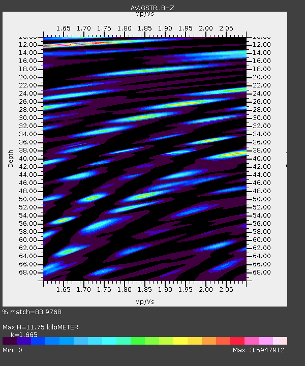
| Estimated Moho Depth: |
11.75 km |
| Estimated Crust Vp/Vs: |
1.66 |
| Assumed Crust Vp: |
3.912 km/s |
| Estimated Crust Vs: |
2.349 km/s |
| Estimated Crust Poisson's Ratio: |
0.22 |
|
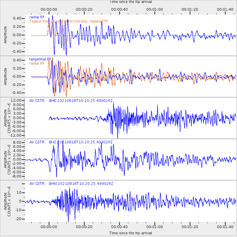
| Radial Match: |
83.9768 % |
| Radial Bump: |
400 |
| Transverse Match: |
84.515785 % |
| Transverse Bump: |
400 |
| SOD ConfigId: |
25131211 |
| Insert Time: |
2021-09-01 10:17:01.572 +0000 |
| GWidth: |
2.5 |
| Max Bumps: |
400 |
| Tol: |
0.001 |
|
Signal To Noise
| Channel | StoN | STA | LTA |
| AV:GSTR: :BHZ:20210818T10:20:25.499026Z | 13.638157 | 3.7208133E-6 | 2.7282377E-7 |
| AV:GSTR: :BHN:20210818T10:20:25.499026Z | 1.9320999 | 2.1309406E-6 | 1.1029143E-6 |
| AV:GSTR: :BHE:20210818T10:20:25.499026Z | 3.760128 | 1.8288572E-6 | 4.863816E-7 |
| Arrivals |
| Ps | 2.0 SECOND |
| PpPs | 7.9 SECOND |
| PsPs/PpSs | 9.9 SECOND |


