You are here: Home > Network List > AV - Alaska Volcano Observatory Stations List
> Station KOKL Mount Kliuchef, Korovin Volcano, Alaska > Earthquake Result Viewer
KOKL Mount Kliuchef, Korovin Volcano, Alaska - Earthquake Result Viewer
| Earthquake location: |
Vanuatu Islands |
| Earthquake latitude/longitude: |
-14.9/167.1 |
| Earthquake time(UTC): |
2021/08/18 (230) 10:10:05 GMT |
| Earthquake Depth: |
91 km |
| Earthquake Magnitude: |
6.8 mww |
| Earthquake Catalog/Contributor: |
NEIC PDE/us |
|
| Network: |
AV Alaska Volcano Observatory |
| Station: |
KOKL Mount Kliuchef, Korovin Volcano, Alaska |
| Lat/Lon: |
52.32 N/174.20 W |
| Elevation: |
758 m |
|
| Distance: |
68.9 deg |
| Az: |
12.187 deg |
| Baz: |
199.423 deg |
| Ray Param: |
0.055796724 |
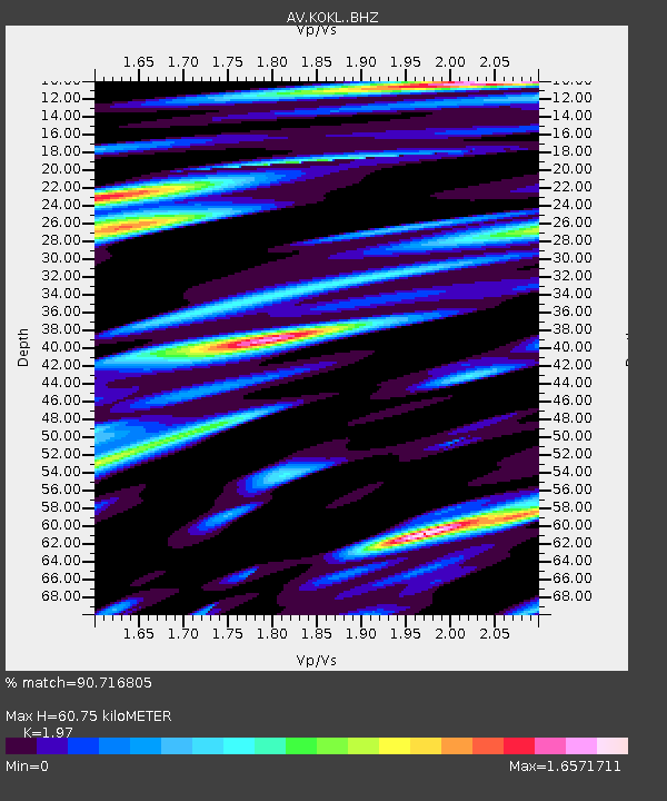
| Estimated Moho Depth: |
60.75 km |
| Estimated Crust Vp/Vs: |
1.97 |
| Assumed Crust Vp: |
5.88 km/s |
| Estimated Crust Vs: |
2.985 km/s |
| Estimated Crust Poisson's Ratio: |
0.33 |
|
| Radial Match: |
90.716805 % |
| Radial Bump: |
400 |
| Transverse Match: |
84.83183 % |
| Transverse Bump: |
400 |
| SOD ConfigId: |
25131211 |
| Insert Time: |
2021-09-01 10:17:29.022 +0000 |
| GWidth: |
2.5 |
| Max Bumps: |
400 |
| Tol: |
0.001 |
|

Signal To Noise
| Channel | StoN | STA | LTA |
| AV:KOKL: :BHZ:20210818T10:20:29.099979Z | 19.767635 | 2.7124759E-6 | 1.3721802E-7 |
| AV:KOKL: :BHN:20210818T10:20:29.099979Z | 5.016957 | 1.8314627E-6 | 3.650545E-7 |
| AV:KOKL: :BHE:20210818T10:20:29.099979Z | 3.6770747 | 1.1082088E-6 | 3.0138327E-7 |
| Arrivals |
| Ps | 10 SECOND |
| PpPs | 30 SECOND |
| PsPs/PpSs | 40 SECOND |


