You are here: Home > Network List > AV - Alaska Volcano Observatory Stations List
> Station TAFL Flats, Tanaga Volcano, Alaska > Earthquake Result Viewer
TAFL Flats, Tanaga Volcano, Alaska - Earthquake Result Viewer
| Earthquake location: |
Vanuatu Islands |
| Earthquake latitude/longitude: |
-14.9/167.1 |
| Earthquake time(UTC): |
2021/08/18 (230) 10:10:05 GMT |
| Earthquake Depth: |
91 km |
| Earthquake Magnitude: |
6.8 mww |
| Earthquake Catalog/Contributor: |
NEIC PDE/us |
|
| Network: |
AV Alaska Volcano Observatory |
| Station: |
TAFL Flats, Tanaga Volcano, Alaska |
| Lat/Lon: |
51.76 N/177.90 W |
| Elevation: |
186 m |
|
| Distance: |
67.6 deg |
| Az: |
10.028 deg |
| Baz: |
195.715 deg |
| Ray Param: |
0.05660032 |
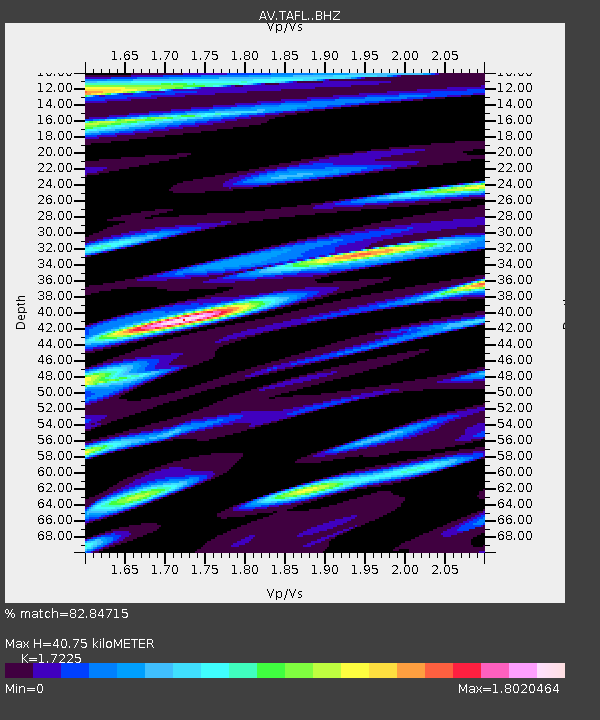
| Estimated Moho Depth: |
40.75 km |
| Estimated Crust Vp/Vs: |
1.72 |
| Assumed Crust Vp: |
5.88 km/s |
| Estimated Crust Vs: |
3.414 km/s |
| Estimated Crust Poisson's Ratio: |
0.25 |
|
| Radial Match: |
82.84715 % |
| Radial Bump: |
400 |
| Transverse Match: |
83.35381 % |
| Transverse Bump: |
400 |
| SOD ConfigId: |
25131211 |
| Insert Time: |
2021-09-01 10:18:30.734 +0000 |
| GWidth: |
2.5 |
| Max Bumps: |
400 |
| Tol: |
0.001 |
|

Signal To Noise
| Channel | StoN | STA | LTA |
| AV:TAFL: :BHZ:20210818T10:20:21.440005Z | 17.527393 | 4.3079135E-6 | 2.4578176E-7 |
| AV:TAFL: :BHN:20210818T10:20:21.440005Z | 2.645195 | 1.6754857E-6 | 6.3340724E-7 |
| AV:TAFL: :BHE:20210818T10:20:21.440005Z | 2.0257957 | 9.0508223E-7 | 4.467786E-7 |
| Arrivals |
| Ps | 5.2 SECOND |
| PpPs | 18 SECOND |
| PsPs/PpSs | 23 SECOND |


