You are here: Home > Network List > CN - Canadian National Seismograph Network Stations List
> Station LLLB Lillooet, BC, CA > Earthquake Result Viewer
LLLB Lillooet, BC, CA - Earthquake Result Viewer
| Earthquake location: |
Vanuatu Islands |
| Earthquake latitude/longitude: |
-14.9/167.1 |
| Earthquake time(UTC): |
2021/08/18 (230) 10:10:05 GMT |
| Earthquake Depth: |
91 km |
| Earthquake Magnitude: |
6.8 mww |
| Earthquake Catalog/Contributor: |
NEIC PDE/us |
|
| Network: |
CN Canadian National Seismograph Network |
| Station: |
LLLB Lillooet, BC, CA |
| Lat/Lon: |
50.61 N/121.88 W |
| Elevation: |
700 m |
|
| Distance: |
89.8 deg |
| Az: |
37.054 deg |
| Baz: |
246.114 deg |
| Ray Param: |
0.041724216 |
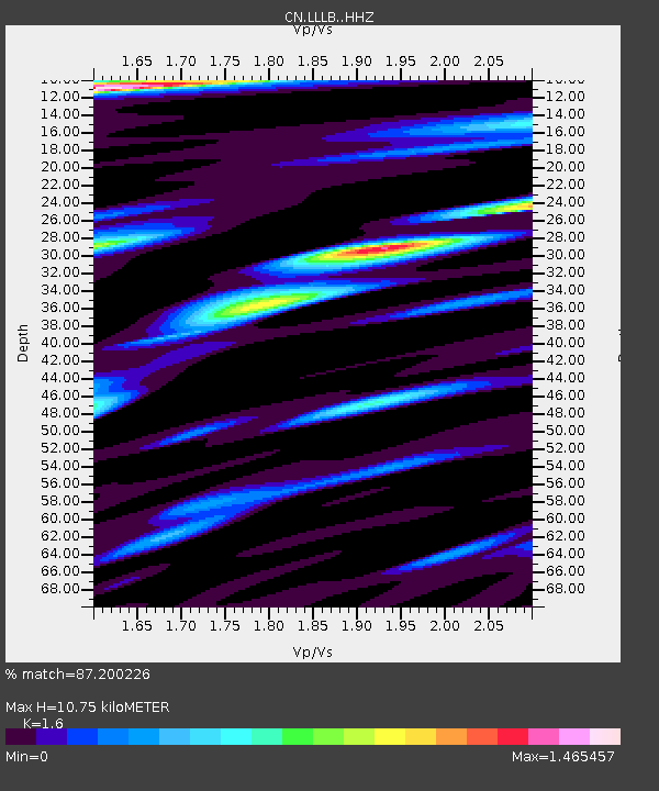
| Estimated Moho Depth: |
10.75 km |
| Estimated Crust Vp/Vs: |
1.60 |
| Assumed Crust Vp: |
6.597 km/s |
| Estimated Crust Vs: |
4.123 km/s |
| Estimated Crust Poisson's Ratio: |
0.18 |
|
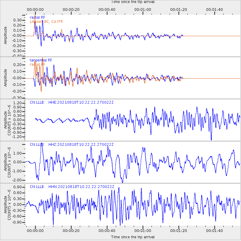
| Radial Match: |
87.200226 % |
| Radial Bump: |
400 |
| Transverse Match: |
68.958 % |
| Transverse Bump: |
400 |
| SOD ConfigId: |
25131211 |
| Insert Time: |
2021-09-01 10:23:58.603 +0000 |
| GWidth: |
2.5 |
| Max Bumps: |
400 |
| Tol: |
0.001 |
|
Signal To Noise
| Channel | StoN | STA | LTA |
| CN:LLLB: :HHZ:20210818T10:22:22.270022Z | 11.479857 | 1.233672E-6 | 1.07464054E-7 |
| CN:LLLB: :HHN:20210818T10:22:22.270022Z | 1.6998186 | 1.7542374E-7 | 1.03201444E-7 |
| CN:LLLB: :HHE:20210818T10:22:22.270022Z | 4.372211 | 3.5525605E-7 | 8.1253184E-8 |
| Arrivals |
| Ps | 1.0 SECOND |
| PpPs | 4.1 SECOND |
| PsPs/PpSs | 5.1 SECOND |


