You are here: Home > Network List > G - GEOSCOPE Stations List
> Station DRV Dumont d'Urville, Terre Adelie (Antartica) > Earthquake Result Viewer
DRV Dumont d'Urville, Terre Adelie (Antartica) - Earthquake Result Viewer
| Earthquake location: |
Vanuatu Islands |
| Earthquake latitude/longitude: |
-14.9/167.1 |
| Earthquake time(UTC): |
2021/08/18 (230) 10:10:05 GMT |
| Earthquake Depth: |
91 km |
| Earthquake Magnitude: |
6.8 mww |
| Earthquake Catalog/Contributor: |
NEIC PDE/us |
|
| Network: |
G GEOSCOPE |
| Station: |
DRV Dumont d'Urville, Terre Adelie (Antartica) |
| Lat/Lon: |
66.67 S/140.01 E |
| Elevation: |
40 m |
|
| Distance: |
54.7 deg |
| Az: |
192.828 deg |
| Baz: |
32.608 deg |
| Ray Param: |
0.06497785 |
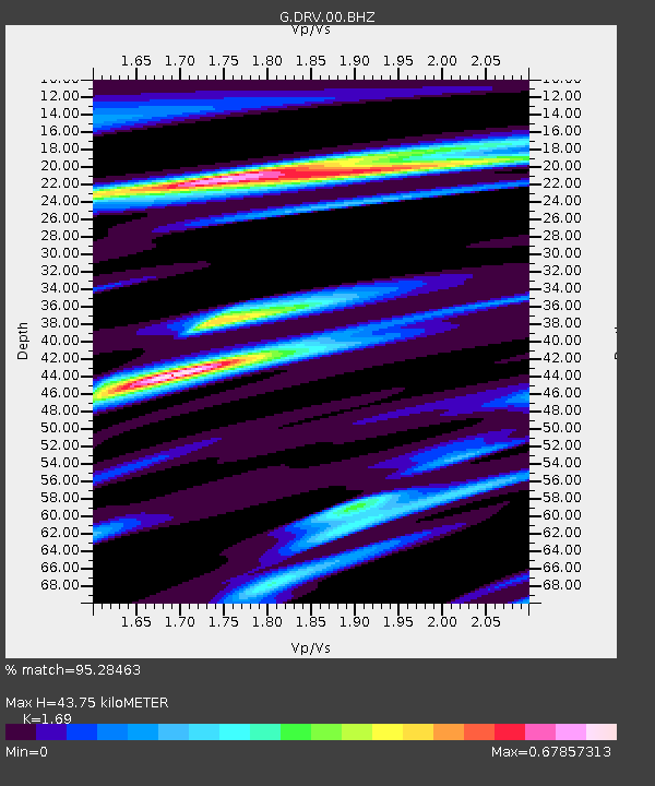
| Estimated Moho Depth: |
43.75 km |
| Estimated Crust Vp/Vs: |
1.69 |
| Assumed Crust Vp: |
6.39 km/s |
| Estimated Crust Vs: |
3.781 km/s |
| Estimated Crust Poisson's Ratio: |
0.23 |
|
| Radial Match: |
95.28463 % |
| Radial Bump: |
246 |
| Transverse Match: |
71.28897 % |
| Transverse Bump: |
400 |
| SOD ConfigId: |
25131211 |
| Insert Time: |
2021-09-01 10:24:58.620 +0000 |
| GWidth: |
2.5 |
| Max Bumps: |
400 |
| Tol: |
0.001 |
|

Signal To Noise
| Channel | StoN | STA | LTA |
| G:DRV:00:BHZ:20210818T10:18:54.599979Z | 16.953918 | 9.842359E-6 | 5.805359E-7 |
| G:DRV:00:BHN:20210818T10:18:54.599979Z | 17.478642 | 4.8229736E-6 | 2.7593526E-7 |
| G:DRV:00:BHE:20210818T10:18:54.599979Z | 8.122025 | 3.4989307E-6 | 4.307954E-7 |
| Arrivals |
| Ps | 5.0 SECOND |
| PpPs | 17 SECOND |
| PsPs/PpSs | 22 SECOND |


