You are here: Home > Network List > IM - International Miscellaneous Stations Stations List
> Station SHEM Shemya Island, Alaska, USA > Earthquake Result Viewer
SHEM Shemya Island, Alaska, USA - Earthquake Result Viewer
| Earthquake location: |
Vanuatu Islands |
| Earthquake latitude/longitude: |
-14.9/167.1 |
| Earthquake time(UTC): |
2021/08/18 (230) 10:10:05 GMT |
| Earthquake Depth: |
91 km |
| Earthquake Magnitude: |
6.8 mww |
| Earthquake Catalog/Contributor: |
NEIC PDE/us |
|
| Network: |
IM International Miscellaneous Stations |
| Station: |
SHEM Shemya Island, Alaska, USA |
| Lat/Lon: |
52.73 N/174.10 E |
| Elevation: |
580 m |
|
| Distance: |
67.6 deg |
| Az: |
4.607 deg |
| Baz: |
187.336 deg |
| Ray Param: |
0.056619685 |
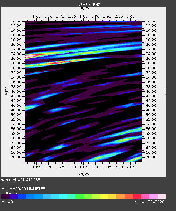
| Estimated Moho Depth: |
25.25 km |
| Estimated Crust Vp/Vs: |
1.60 |
| Assumed Crust Vp: |
3.999 km/s |
| Estimated Crust Vs: |
2.499 km/s |
| Estimated Crust Poisson's Ratio: |
0.18 |
|
| Radial Match: |
91.411255 % |
| Radial Bump: |
400 |
| Transverse Match: |
83.520744 % |
| Transverse Bump: |
400 |
| SOD ConfigId: |
25131211 |
| Insert Time: |
2021-09-01 10:26:32.866 +0000 |
| GWidth: |
2.5 |
| Max Bumps: |
400 |
| Tol: |
0.001 |
|

Signal To Noise
| Channel | StoN | STA | LTA |
| IM:SHEM: :BHZ:20210818T10:20:21.27399Z | 20.858036 | 5.921028E-6 | 2.8387274E-7 |
| IM:SHEM: :BHN:20210818T10:20:21.27399Z | 10.022605 | 2.7131807E-6 | 2.7070612E-7 |
| IM:SHEM: :BHE:20210818T10:20:21.27399Z | 1.3715436 | 5.973382E-7 | 4.355226E-7 |
| Arrivals |
| Ps | 3.9 SECOND |
| PpPs | 16 SECOND |
| PsPs/PpSs | 20 SECOND |


