You are here: Home > Network List > UW - Pacific Northwest Regional Seismic Network Stations List
> Station IRON Crane, OR, USA > Earthquake Result Viewer
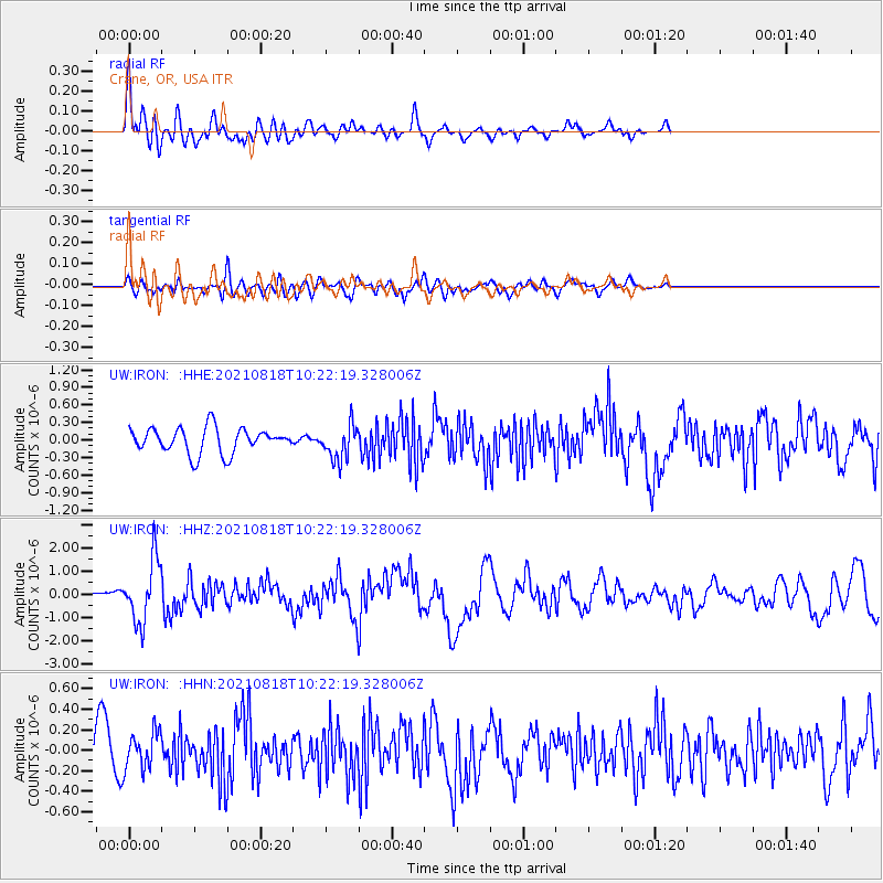
IRON Crane, OR, USA - Earthquake Result Viewer
*The percent match for this event was below the threshold and hence no stack was calculated.
| Earthquake location: |
Vanuatu Islands |
| Earthquake latitude/longitude: |
-14.9/167.1 |
| Earthquake time(UTC): |
2021/08/18 (230) 10:10:05 GMT |
| Earthquake Depth: |
91 km |
| Earthquake Magnitude: |
6.8 mww |
| Earthquake Catalog/Contributor: |
NEIC PDE/us |
|
| Network: |
UW Pacific Northwest Regional Seismic Network |
| Station: |
IRON Crane, OR, USA |
| Lat/Lon: |
43.36 N/118.47 W |
| Elevation: |
1226 m |
|
| Distance: |
89.2 deg |
| Az: |
44.646 deg |
| Baz: |
248.67 deg |
| Ray Param: |
$rayparam |
*The percent match for this event was below the threshold and hence was not used in the summary stack. |
|
| Radial Match: |
71.21664 % |
| Radial Bump: |
400 |
| Transverse Match: |
67.669586 % |
| Transverse Bump: |
400 |
| SOD ConfigId: |
25131211 |
| Insert Time: |
2021-09-01 10:34:53.636 +0000 |
| GWidth: |
2.5 |
| Max Bumps: |
400 |
| Tol: |
0.001 |
|
Signal To Noise
| Channel | StoN | STA | LTA |
| UW:IRON: :HHZ:20210818T10:22:19.328006Z | 6.0771914 | 1.355735E-6 | 2.2308578E-7 |
| UW:IRON: :HHN:20210818T10:22:19.328006Z | 1.3036971 | 1.8496578E-7 | 1.4187789E-7 |
| UW:IRON: :HHE:20210818T10:22:19.328006Z | 1.3954055 | 3.014429E-7 | 2.160253E-7 |
| Arrivals |
| Ps | |
| PpPs | |
| PsPs/PpSs | |


