You are here: Home > Network List > AU - Australian Seismological Centre Stations List
> Station KLBR Kellerberrin, Western Australia > Earthquake Result Viewer
KLBR Kellerberrin, Western Australia - Earthquake Result Viewer
| Earthquake location: |
South Sandwich Islands Region |
| Earthquake latitude/longitude: |
-59.7/-26.4 |
| Earthquake time(UTC): |
2021/08/18 (230) 21:49:57 GMT |
| Earthquake Depth: |
38 km |
| Earthquake Magnitude: |
5.9 mww |
| Earthquake Catalog/Contributor: |
NEIC PDE/us |
|
| Network: |
AU Australian Seismological Centre |
| Station: |
KLBR Kellerberrin, Western Australia |
| Lat/Lon: |
31.59 S/117.75 E |
| Elevation: |
320 m |
|
| Distance: |
84.3 deg |
| Az: |
149.83 deg |
| Baz: |
197.369 deg |
| Ray Param: |
0.045509525 |
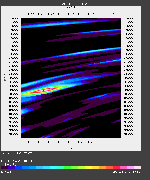
| Estimated Moho Depth: |
46.0 km |
| Estimated Crust Vp/Vs: |
1.71 |
| Assumed Crust Vp: |
6.419 km/s |
| Estimated Crust Vs: |
3.754 km/s |
| Estimated Crust Poisson's Ratio: |
0.24 |
|
| Radial Match: |
80.72509 % |
| Radial Bump: |
400 |
| Transverse Match: |
70.482994 % |
| Transverse Bump: |
400 |
| SOD ConfigId: |
25131211 |
| Insert Time: |
2021-09-01 21:50:41.242 +0000 |
| GWidth: |
2.5 |
| Max Bumps: |
400 |
| Tol: |
0.001 |
|

Signal To Noise
| Channel | StoN | STA | LTA |
| AU:KLBR:00:HHZ:20210818T22:01:54.029982Z | 3.790161 | 1.2747422E-6 | 3.3632932E-7 |
| AU:KLBR:00:HHN:20210818T22:01:54.029982Z | 1.4752421 | 4.38239E-7 | 2.9706243E-7 |
| AU:KLBR:00:HHE:20210818T22:01:54.029982Z | 1.032869 | 3.4071928E-7 | 3.298766E-7 |
| Arrivals |
| Ps | 5.2 SECOND |
| PpPs | 19 SECOND |
| PsPs/PpSs | 24 SECOND |


