You are here: Home > Network List > AU - Australian Seismological Centre Stations List
> Station KLBR Kellerberrin, Western Australia > Earthquake Result Viewer
KLBR Kellerberrin, Western Australia - Earthquake Result Viewer
| Earthquake location: |
South Sandwich Islands Region |
| Earthquake latitude/longitude: |
-60.1/-24.3 |
| Earthquake time(UTC): |
2021/08/22 (234) 00:45:08 GMT |
| Earthquake Depth: |
11 km |
| Earthquake Magnitude: |
6.8 mww |
| Earthquake Catalog/Contributor: |
NEIC PDE/us |
|
| Network: |
AU Australian Seismological Centre |
| Station: |
KLBR Kellerberrin, Western Australia |
| Lat/Lon: |
31.59 S/117.75 E |
| Elevation: |
320 m |
|
| Distance: |
83.4 deg |
| Az: |
148.152 deg |
| Baz: |
198.034 deg |
| Ray Param: |
0.046184126 |
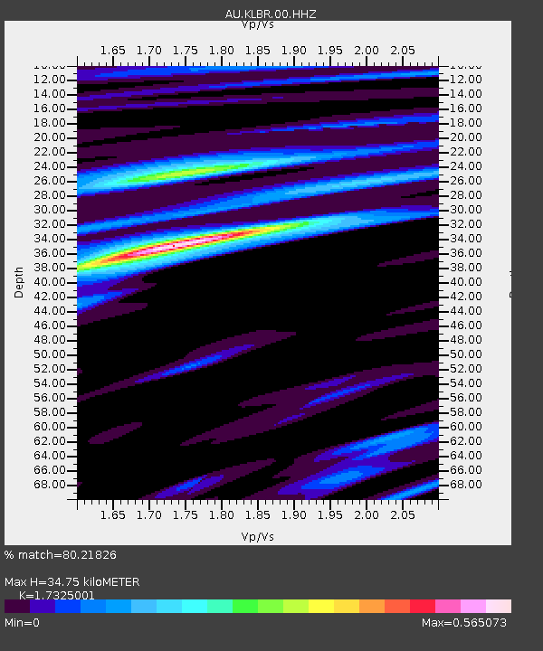
| Estimated Moho Depth: |
34.75 km |
| Estimated Crust Vp/Vs: |
1.73 |
| Assumed Crust Vp: |
6.419 km/s |
| Estimated Crust Vs: |
3.705 km/s |
| Estimated Crust Poisson's Ratio: |
0.25 |
|
| Radial Match: |
80.21826 % |
| Radial Bump: |
400 |
| Transverse Match: |
70.36769 % |
| Transverse Bump: |
400 |
| SOD ConfigId: |
25131211 |
| Insert Time: |
2021-09-05 00:45:57.001 +0000 |
| GWidth: |
2.5 |
| Max Bumps: |
400 |
| Tol: |
0.001 |
|

Signal To Noise
| Channel | StoN | STA | LTA |
| AU:KLBR:00:HHZ:20210822T00:57:04.180013Z | 12.475179 | 8.761446E-6 | 7.0231033E-7 |
| AU:KLBR:00:HHN:20210822T00:57:04.180013Z | 5.504906 | 2.3917034E-6 | 4.344676E-7 |
| AU:KLBR:00:HHE:20210822T00:57:04.180013Z | 1.539319 | 1.1084239E-6 | 7.200742E-7 |
| Arrivals |
| Ps | 4.1 SECOND |
| PpPs | 14 SECOND |
| PsPs/PpSs | 18 SECOND |


