You are here: Home > Network List > BL - Brazilian Lithospheric Seismic Project (BLSP) Stations List
> Station PMNB Patos de Minas, MG > Earthquake Result Viewer
PMNB Patos de Minas, MG - Earthquake Result Viewer
| Earthquake location: |
South Sandwich Islands Region |
| Earthquake latitude/longitude: |
-60.1/-24.3 |
| Earthquake time(UTC): |
2021/08/22 (234) 00:45:08 GMT |
| Earthquake Depth: |
11 km |
| Earthquake Magnitude: |
6.8 mww |
| Earthquake Catalog/Contributor: |
NEIC PDE/us |
|
| Network: |
BL Brazilian Lithospheric Seismic Project (BLSP) |
| Station: |
PMNB Patos de Minas, MG |
| Lat/Lon: |
18.54 S/46.44 W |
| Elevation: |
950 m |
|
| Distance: |
44.5 deg |
| Az: |
329.37 deg |
| Baz: |
164.403 deg |
| Ray Param: |
0.07191478 |
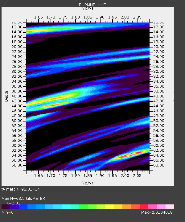
| Estimated Moho Depth: |
63.5 km |
| Estimated Crust Vp/Vs: |
2.02 |
| Assumed Crust Vp: |
6.419 km/s |
| Estimated Crust Vs: |
3.178 km/s |
| Estimated Crust Poisson's Ratio: |
0.34 |
|
| Radial Match: |
96.31734 % |
| Radial Bump: |
273 |
| Transverse Match: |
80.04566 % |
| Transverse Bump: |
400 |
| SOD ConfigId: |
25131211 |
| Insert Time: |
2021-09-05 00:46:22.032 +0000 |
| GWidth: |
2.5 |
| Max Bumps: |
400 |
| Tol: |
0.001 |
|

Signal To Noise
| Channel | StoN | STA | LTA |
| BL:PMNB: :HHZ:20210822T00:52:48.339986Z | 5.2226243 | 2.0729647E-6 | 3.9692011E-7 |
| BL:PMNB: :HHN:20210822T00:52:48.339986Z | 4.2177052 | 1.328113E-6 | 3.1488995E-7 |
| BL:PMNB: :HHE:20210822T00:52:48.339986Z | 1.2886895 | 3.5328725E-7 | 2.7414458E-7 |
| Arrivals |
| Ps | 11 SECOND |
| PpPs | 28 SECOND |
| PsPs/PpSs | 39 SECOND |


