You are here: Home > Network List > CM - Red Sismologica Nacional de Columbia Stations List
> Station SMAR Santa Marta, Magdalena, Colombia > Earthquake Result Viewer
SMAR Santa Marta, Magdalena, Colombia - Earthquake Result Viewer
| Earthquake location: |
South Sandwich Islands Region |
| Earthquake latitude/longitude: |
-60.1/-24.3 |
| Earthquake time(UTC): |
2021/08/22 (234) 00:45:08 GMT |
| Earthquake Depth: |
11 km |
| Earthquake Magnitude: |
6.8 mww |
| Earthquake Catalog/Contributor: |
NEIC PDE/us |
|
| Network: |
CM Red Sismologica Nacional de Columbia |
| Station: |
SMAR Santa Marta, Magdalena, Colombia |
| Lat/Lon: |
11.16 N/74.22 W |
| Elevation: |
122 m |
|
| Distance: |
81.4 deg |
| Az: |
310.623 deg |
| Baz: |
157.216 deg |
| Ray Param: |
0.04764087 |
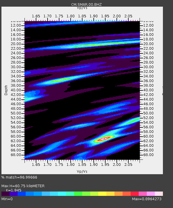
| Estimated Moho Depth: |
60.75 km |
| Estimated Crust Vp/Vs: |
1.95 |
| Assumed Crust Vp: |
5.129 km/s |
| Estimated Crust Vs: |
2.637 km/s |
| Estimated Crust Poisson's Ratio: |
0.32 |
|
| Radial Match: |
96.99666 % |
| Radial Bump: |
271 |
| Transverse Match: |
90.07993 % |
| Transverse Bump: |
400 |
| SOD ConfigId: |
25131211 |
| Insert Time: |
2021-09-05 00:48:04.300 +0000 |
| GWidth: |
2.5 |
| Max Bumps: |
400 |
| Tol: |
0.001 |
|

Signal To Noise
| Channel | StoN | STA | LTA |
| CM:SMAR:00:BHZ:20210822T00:56:53.368978Z | 22.564514 | 2.523398E-6 | 1.1183037E-7 |
| CM:SMAR:00:BHN:20210822T00:56:53.368978Z | 9.080866 | 9.755034E-7 | 1.0742406E-7 |
| CM:SMAR:00:BHE:20210822T00:56:53.368978Z | 4.661491 | 5.360744E-7 | 1.1500063E-7 |
| Arrivals |
| Ps | 11 SECOND |
| PpPs | 34 SECOND |
| PsPs/PpSs | 46 SECOND |


