You are here: Home > Network List > G - GEOSCOPE Stations List
> Station MPG Montagne des Peres, French Guyana > Earthquake Result Viewer
MPG Montagne des Peres, French Guyana - Earthquake Result Viewer
| Earthquake location: |
South Sandwich Islands Region |
| Earthquake latitude/longitude: |
-60.1/-24.3 |
| Earthquake time(UTC): |
2021/08/22 (234) 00:45:08 GMT |
| Earthquake Depth: |
11 km |
| Earthquake Magnitude: |
6.8 mww |
| Earthquake Catalog/Contributor: |
NEIC PDE/us |
|
| Network: |
G GEOSCOPE |
| Station: |
MPG Montagne des Peres, French Guyana |
| Lat/Lon: |
5.11 N/52.64 W |
| Elevation: |
147 m |
|
| Distance: |
68.7 deg |
| Az: |
329.556 deg |
| Baz: |
165.245 deg |
| Ray Param: |
0.056107737 |
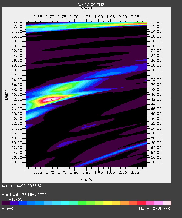
| Estimated Moho Depth: |
41.75 km |
| Estimated Crust Vp/Vs: |
1.71 |
| Assumed Crust Vp: |
6.472 km/s |
| Estimated Crust Vs: |
3.796 km/s |
| Estimated Crust Poisson's Ratio: |
0.24 |
|
| Radial Match: |
98.236664 % |
| Radial Bump: |
273 |
| Transverse Match: |
88.93319 % |
| Transverse Bump: |
400 |
| SOD ConfigId: |
25131211 |
| Insert Time: |
2021-09-05 00:48:59.095 +0000 |
| GWidth: |
2.5 |
| Max Bumps: |
400 |
| Tol: |
0.001 |
|

Signal To Noise
| Channel | StoN | STA | LTA |
| G:MPG:00:BHZ:20210822T00:55:40.75002Z | 22.868805 | 2.9591552E-6 | 1.2939702E-7 |
| G:MPG:00:BHN:20210822T00:55:40.75002Z | 12.351399 | 1.0687346E-6 | 8.652741E-8 |
| G:MPG:00:BHE:20210822T00:55:40.75002Z | 4.8304796 | 4.426201E-7 | 9.1630675E-8 |
| Arrivals |
| Ps | 4.7 SECOND |
| PpPs | 17 SECOND |
| PsPs/PpSs | 21 SECOND |


