You are here: Home > Network List > GT - Global Telemetered Seismograph Network (USAF/USGS) Stations List
> Station LPAZ La Paz , Bolivia > Earthquake Result Viewer
LPAZ La Paz , Bolivia - Earthquake Result Viewer
| Earthquake location: |
South Sandwich Islands Region |
| Earthquake latitude/longitude: |
-60.1/-24.3 |
| Earthquake time(UTC): |
2021/08/22 (234) 00:45:08 GMT |
| Earthquake Depth: |
11 km |
| Earthquake Magnitude: |
6.8 mww |
| Earthquake Catalog/Contributor: |
NEIC PDE/us |
|
| Network: |
GT Global Telemetered Seismograph Network (USAF/USGS) |
| Station: |
LPAZ La Paz , Bolivia |
| Lat/Lon: |
16.17 S/68.08 W |
| Elevation: |
4817 m |
|
| Distance: |
54.0 deg |
| Az: |
304.843 deg |
| Baz: |
154.683 deg |
| Ray Param: |
0.06569585 |
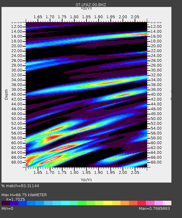
| Estimated Moho Depth: |
66.75 km |
| Estimated Crust Vp/Vs: |
1.70 |
| Assumed Crust Vp: |
6.454 km/s |
| Estimated Crust Vs: |
3.791 km/s |
| Estimated Crust Poisson's Ratio: |
0.24 |
|
| Radial Match: |
93.31144 % |
| Radial Bump: |
400 |
| Transverse Match: |
85.6182 % |
| Transverse Bump: |
400 |
| SOD ConfigId: |
25131211 |
| Insert Time: |
2021-09-05 00:49:26.279 +0000 |
| GWidth: |
2.5 |
| Max Bumps: |
400 |
| Tol: |
0.001 |
|
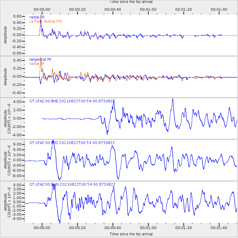
Signal To Noise
| Channel | StoN | STA | LTA |
| GT:LPAZ:00:BHZ:20210822T00:54:00.873982Z | 15.615079 | 1.6566521E-6 | 1.060931E-7 |
| GT:LPAZ:00:BHN:20210822T00:54:00.873982Z | 6.6101336 | 5.7272365E-7 | 8.664328E-8 |
| GT:LPAZ:00:BHE:20210822T00:54:00.873982Z | 6.9183645 | 5.834643E-7 | 8.433559E-8 |
| Arrivals |
| Ps | 7.7 SECOND |
| PpPs | 26 SECOND |
| PsPs/PpSs | 34 SECOND |


