You are here: Home > Network List > WI - West Indies IPGP Network Stations List
> Station DHS Morne Mazeau - Deshaies, Guadeloupe > Earthquake Result Viewer
DHS Morne Mazeau - Deshaies, Guadeloupe - Earthquake Result Viewer
| Earthquake location: |
South Sandwich Islands Region |
| Earthquake latitude/longitude: |
-60.1/-24.3 |
| Earthquake time(UTC): |
2021/08/22 (234) 00:45:08 GMT |
| Earthquake Depth: |
11 km |
| Earthquake Magnitude: |
6.8 mww |
| Earthquake Catalog/Contributor: |
NEIC PDE/us |
|
| Network: |
WI West Indies IPGP Network |
| Station: |
DHS Morne Mazeau - Deshaies, Guadeloupe |
| Lat/Lon: |
16.27 N/61.77 W |
| Elevation: |
618 m |
|
| Distance: |
81.9 deg |
| Az: |
323.878 deg |
| Baz: |
162.103 deg |
| Ray Param: |
0.047260776 |
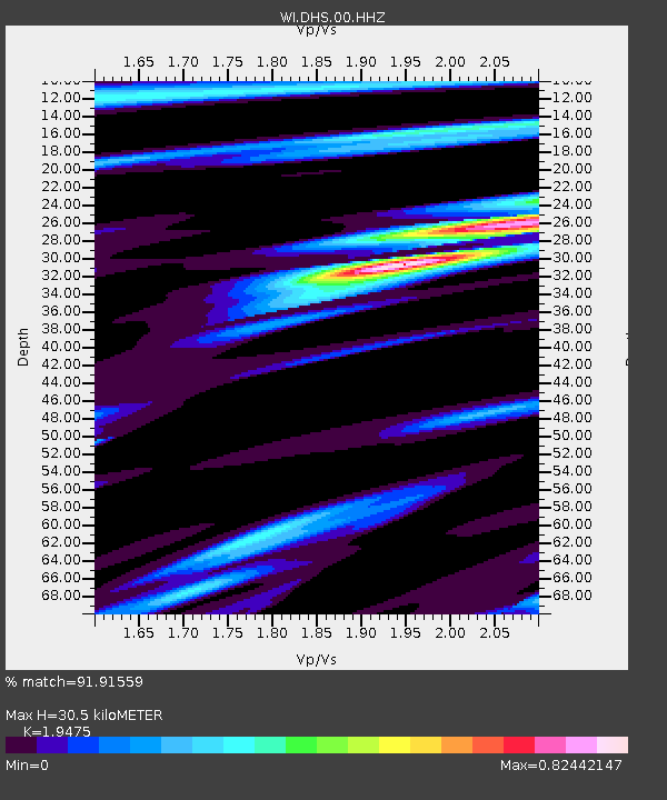
| Estimated Moho Depth: |
30.5 km |
| Estimated Crust Vp/Vs: |
1.95 |
| Assumed Crust Vp: |
6.048 km/s |
| Estimated Crust Vs: |
3.105 km/s |
| Estimated Crust Poisson's Ratio: |
0.32 |
|
| Radial Match: |
91.91559 % |
| Radial Bump: |
400 |
| Transverse Match: |
70.38665 % |
| Transverse Bump: |
400 |
| SOD ConfigId: |
25131211 |
| Insert Time: |
2021-09-05 00:52:35.808 +0000 |
| GWidth: |
2.5 |
| Max Bumps: |
400 |
| Tol: |
0.001 |
|

Signal To Noise
| Channel | StoN | STA | LTA |
| WI:DHS:00:HHZ:20210822T00:56:56.26003Z | 13.755873 | 6.182373E-6 | 4.4943516E-7 |
| WI:DHS:00:HHN:20210822T00:56:56.26003Z | 2.6587331 | 1.9526071E-6 | 7.344126E-7 |
| WI:DHS:00:HHE:20210822T00:56:56.26003Z | 0.6964094 | 6.994617E-7 | 1.0043829E-6 |
| Arrivals |
| Ps | 4.9 SECOND |
| PpPs | 15 SECOND |
| PsPs/PpSs | 19 SECOND |


