You are here: Home > Network List > C1 - Red Sismologica Nacional Stations List
> Station MT14 Calan > Earthquake Result Viewer
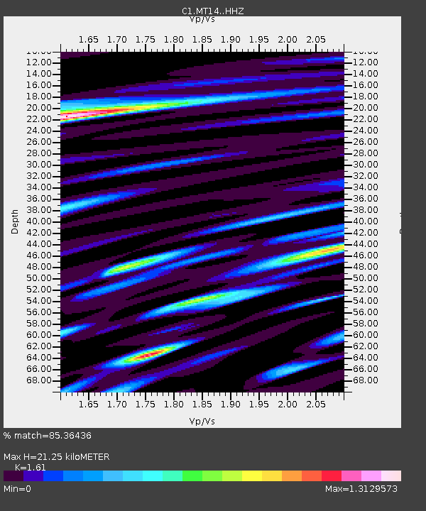
MT14 Calan - Earthquake Result Viewer
| Earthquake location: |
South Sandwich Islands Region |
| Earthquake latitude/longitude: |
-60.3/-24.9 |
| Earthquake time(UTC): |
2021/08/22 (234) 21:33:20 GMT |
| Earthquake Depth: |
14 km |
| Earthquake Magnitude: |
7.1 mww |
| Earthquake Catalog/Contributor: |
NEIC PDE/us |
|
| Network: |
C1 Red Sismologica Nacional |
| Station: |
MT14 Calan |
| Lat/Lon: |
33.40 S/70.54 W |
| Elevation: |
856 m |
|
| Distance: |
40.0 deg |
| Az: |
291.391 deg |
| Baz: |
146.331 deg |
| Ray Param: |
0.074658506 |
| Estimated Moho Depth: |
21.25 km |
| Estimated Crust Vp/Vs: |
1.61 |
| Assumed Crust Vp: |
6.481 km/s |
| Estimated Crust Vs: |
4.025 km/s |
| Estimated Crust Poisson's Ratio: |
0.19 |
|
| Radial Match: |
85.36436 % |
| Radial Bump: |
400 |
| Transverse Match: |
87.39277 % |
| Transverse Bump: |
400 |
| SOD ConfigId: |
25131211 |
| Insert Time: |
2021-09-05 21:35:37.481 +0000 |
| GWidth: |
2.5 |
| Max Bumps: |
400 |
| Tol: |
0.001 |
|

Signal To Noise
| Channel | StoN | STA | LTA |
| C1:MT14: :HHZ:20210822T21:40:23.323001Z | 12.9583025 | 1.0014707E-5 | 7.72841E-7 |
| C1:MT14: :HHN:20210822T21:40:23.323001Z | 4.42434 | 4.2220154E-6 | 9.542703E-7 |
| C1:MT14: :HHE:20210822T21:40:23.323001Z | 3.2693427 | 2.2700945E-6 | 6.9435805E-7 |
| Arrivals |
| Ps | 2.2 SECOND |
| PpPs | 7.9 SECOND |
| PsPs/PpSs | 10 SECOND |


