You are here: Home > Network List > C1 - Red Sismologica Nacional Stations List
> Station TA01 Daracena > Earthquake Result Viewer
TA01 Daracena - Earthquake Result Viewer
| Earthquake location: |
South Sandwich Islands Region |
| Earthquake latitude/longitude: |
-60.3/-24.9 |
| Earthquake time(UTC): |
2021/08/22 (234) 21:33:20 GMT |
| Earthquake Depth: |
14 km |
| Earthquake Magnitude: |
7.1 mww |
| Earthquake Catalog/Contributor: |
NEIC PDE/us |
|
| Network: |
C1 Red Sismologica Nacional |
| Station: |
TA01 Daracena |
| Lat/Lon: |
20.57 S/70.18 W |
| Elevation: |
616 m |
|
| Distance: |
50.9 deg |
| Az: |
300.85 deg |
| Baz: |
152.848 deg |
| Ray Param: |
0.06776249 |
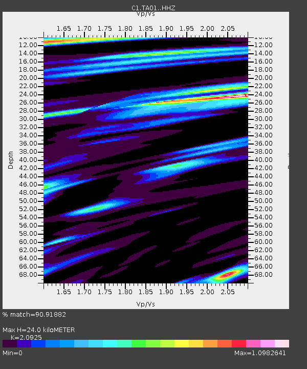
| Estimated Moho Depth: |
24.0 km |
| Estimated Crust Vp/Vs: |
2.09 |
| Assumed Crust Vp: |
4.24 km/s |
| Estimated Crust Vs: |
2.026 km/s |
| Estimated Crust Poisson's Ratio: |
0.35 |
|
| Radial Match: |
90.91882 % |
| Radial Bump: |
377 |
| Transverse Match: |
77.44852 % |
| Transverse Bump: |
400 |
| SOD ConfigId: |
25131211 |
| Insert Time: |
2021-09-05 21:35:43.777 +0000 |
| GWidth: |
2.5 |
| Max Bumps: |
400 |
| Tol: |
0.001 |
|

Signal To Noise
| Channel | StoN | STA | LTA |
| C1:TA01: :HHZ:20210822T21:41:49.489993Z | 6.86353 | 2.268966E-6 | 3.3058296E-7 |
| C1:TA01: :HHN:20210822T21:41:49.489993Z | 2.3030314 | 8.886417E-7 | 3.858574E-7 |
| C1:TA01: :HHE:20210822T21:41:49.489993Z | 1.6968695 | 6.1320725E-7 | 3.613756E-7 |
| Arrivals |
| Ps | 6.3 SECOND |
| PpPs | 17 SECOND |
| PsPs/PpSs | 23 SECOND |


