You are here: Home > Network List > G - GEOSCOPE Stations List
> Station CRZF Port Alfred, Crozet, South Indian Ocean > Earthquake Result Viewer
CRZF Port Alfred, Crozet, South Indian Ocean - Earthquake Result Viewer
| Earthquake location: |
South Sandwich Islands Region |
| Earthquake latitude/longitude: |
-60.3/-24.9 |
| Earthquake time(UTC): |
2021/08/22 (234) 21:33:20 GMT |
| Earthquake Depth: |
14 km |
| Earthquake Magnitude: |
7.1 mww |
| Earthquake Catalog/Contributor: |
NEIC PDE/us |
|
| Network: |
G GEOSCOPE |
| Station: |
CRZF Port Alfred, Crozet, South Indian Ocean |
| Lat/Lon: |
46.43 S/51.86 E |
| Elevation: |
140 m |
|
| Distance: |
45.2 deg |
| Az: |
108.275 deg |
| Baz: |
223.143 deg |
| Ray Param: |
0.071460694 |
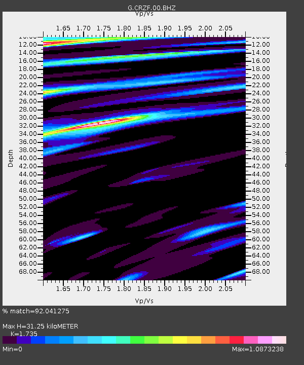
| Estimated Moho Depth: |
31.25 km |
| Estimated Crust Vp/Vs: |
1.74 |
| Assumed Crust Vp: |
4.802 km/s |
| Estimated Crust Vs: |
2.768 km/s |
| Estimated Crust Poisson's Ratio: |
0.25 |
|
| Radial Match: |
92.041275 % |
| Radial Bump: |
400 |
| Transverse Match: |
72.64753 % |
| Transverse Bump: |
400 |
| SOD ConfigId: |
25131211 |
| Insert Time: |
2021-09-05 21:36:39.575 +0000 |
| GWidth: |
2.5 |
| Max Bumps: |
400 |
| Tol: |
0.001 |
|

Signal To Noise
| Channel | StoN | STA | LTA |
| G:CRZF:00:BHZ:20210822T21:41:05.450015Z | 3.3837914 | 2.8793856E-6 | 8.509347E-7 |
| G:CRZF:00:BHN:20210822T21:41:05.450015Z | 1.4988891 | 1.6078791E-6 | 1.0727139E-6 |
| G:CRZF:00:BHE:20210822T21:41:05.450015Z | 1.1794815 | 1.393296E-6 | 1.1812783E-6 |
| Arrivals |
| Ps | 5.0 SECOND |
| PpPs | 17 SECOND |
| PsPs/PpSs | 22 SECOND |


