You are here: Home > Network List > G - GEOSCOPE Stations List
> Station FOMA Nahampoana reservation, Fort Dauphin, Madagascar > Earthquake Result Viewer
FOMA Nahampoana reservation, Fort Dauphin, Madagascar - Earthquake Result Viewer

| Earthquake location: |
South Sandwich Islands Region |
| Earthquake latitude/longitude: |
-60.3/-24.9 |
| Earthquake time(UTC): |
2021/08/22 (234) 21:33:20 GMT |
| Earthquake Depth: |
14 km |
| Earthquake Magnitude: |
7.1 mww |
| Earthquake Catalog/Contributor: |
NEIC PDE/us |
|
| Network: |
G GEOSCOPE |
| Station: |
FOMA Nahampoana reservation, Fort Dauphin, Madagascar |
| Lat/Lon: |
24.98 S/46.98 E |
| Elevation: |
26 m |
|
| Distance: |
59.7 deg |
| Az: |
87.632 deg |
| Baz: |
213.255 deg |
| Ray Param: |
0.06201766 |
| Estimated Moho Depth: |
35.5 km |
| Estimated Crust Vp/Vs: |
1.62 |
| Assumed Crust Vp: |
6.183 km/s |
| Estimated Crust Vs: |
3.822 km/s |
| Estimated Crust Poisson's Ratio: |
0.19 |
|
| Radial Match: |
94.50017 % |
| Radial Bump: |
400 |
| Transverse Match: |
86.44117 % |
| Transverse Bump: |
400 |
| SOD ConfigId: |
25131211 |
| Insert Time: |
2021-09-05 21:36:44.587 +0000 |
| GWidth: |
2.5 |
| Max Bumps: |
400 |
| Tol: |
0.001 |
|
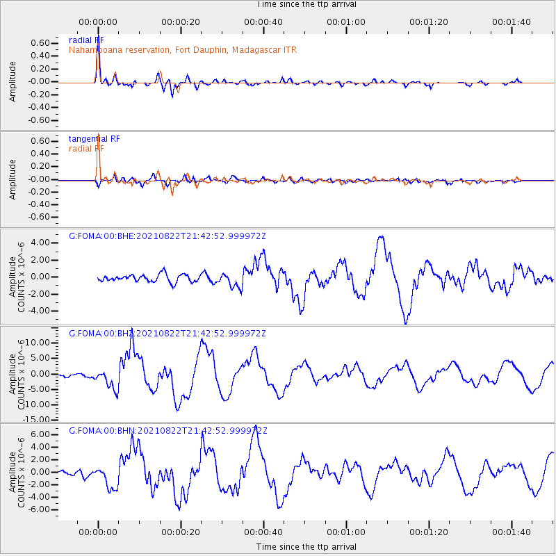
Signal To Noise
| Channel | StoN | STA | LTA |
| G:FOMA:00:BHZ:20210822T21:42:52.999972Z | 8.646714 | 3.3554848E-6 | 3.880647E-7 |
| G:FOMA:00:BHN:20210822T21:42:52.999972Z | 6.038667 | 1.8824461E-6 | 3.1173204E-7 |
| G:FOMA:00:BHE:20210822T21:42:52.999972Z | 2.0158017 | 8.6911155E-7 | 4.3114935E-7 |
| Arrivals |
| Ps | 3.7 SECOND |
| PpPs | 14 SECOND |
| PsPs/PpSs | 18 SECOND |


