You are here: Home > Network List > G - GEOSCOPE Stations List
> Station MPG Montagne des Peres, French Guyana > Earthquake Result Viewer
MPG Montagne des Peres, French Guyana - Earthquake Result Viewer
| Earthquake location: |
South Sandwich Islands Region |
| Earthquake latitude/longitude: |
-60.3/-24.9 |
| Earthquake time(UTC): |
2021/08/22 (234) 21:33:20 GMT |
| Earthquake Depth: |
14 km |
| Earthquake Magnitude: |
7.1 mww |
| Earthquake Catalog/Contributor: |
NEIC PDE/us |
|
| Network: |
G GEOSCOPE |
| Station: |
MPG Montagne des Peres, French Guyana |
| Lat/Lon: |
5.11 N/52.64 W |
| Elevation: |
147 m |
|
| Distance: |
68.8 deg |
| Az: |
330.159 deg |
| Baz: |
165.592 deg |
| Ray Param: |
0.056095757 |
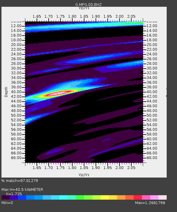
| Estimated Moho Depth: |
40.5 km |
| Estimated Crust Vp/Vs: |
1.74 |
| Assumed Crust Vp: |
6.472 km/s |
| Estimated Crust Vs: |
3.73 km/s |
| Estimated Crust Poisson's Ratio: |
0.25 |
|
| Radial Match: |
97.81279 % |
| Radial Bump: |
328 |
| Transverse Match: |
85.26959 % |
| Transverse Bump: |
400 |
| SOD ConfigId: |
25131211 |
| Insert Time: |
2021-09-05 21:36:47.314 +0000 |
| GWidth: |
2.5 |
| Max Bumps: |
400 |
| Tol: |
0.001 |
|
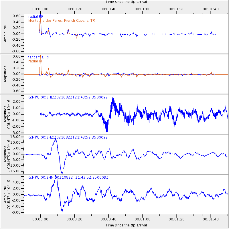
Signal To Noise
| Channel | StoN | STA | LTA |
| G:MPG:00:BHZ:20210822T21:43:52.350009Z | 10.182301 | 1.6728578E-6 | 1.6429075E-7 |
| G:MPG:00:BHN:20210822T21:43:52.350009Z | 7.6356077 | 7.57267E-7 | 9.9175736E-8 |
| G:MPG:00:BHE:20210822T21:43:52.350009Z | 2.4326222 | 3.1645158E-7 | 1.3008662E-7 |
| Arrivals |
| Ps | 4.8 SECOND |
| PpPs | 16 SECOND |
| PsPs/PpSs | 21 SECOND |


