You are here: Home > Network List > IM - International Miscellaneous Stations Stations List
> Station MK31 Makanchi Array Site 31, Kazakhstan > Earthquake Result Viewer
MK31 Makanchi Array Site 31, Kazakhstan - Earthquake Result Viewer
| Earthquake location: |
Santa Cruz Islands |
| Earthquake latitude/longitude: |
-11.6/166.1 |
| Earthquake time(UTC): |
2009/08/10 (222) 04:06:31 GMT |
| Earthquake Depth: |
35 km |
| Earthquake Magnitude: |
5.8 MB, 6.3 MS, 6.6 MW, 6.6 MW |
| Earthquake Catalog/Contributor: |
WHDF/NEIC |
|
| Network: |
IM International Miscellaneous Stations |
| Station: |
MK31 Makanchi Array Site 31, Kazakhstan |
| Lat/Lon: |
46.79 N/82.29 E |
| Elevation: |
618 m |
|
| Distance: |
94.2 deg |
| Az: |
316.776 deg |
| Baz: |
102.408 deg |
| Ray Param: |
0.041093767 |
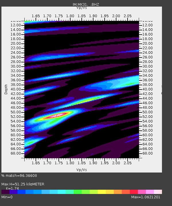
| Estimated Moho Depth: |
51.25 km |
| Estimated Crust Vp/Vs: |
1.74 |
| Assumed Crust Vp: |
6.688 km/s |
| Estimated Crust Vs: |
3.844 km/s |
| Estimated Crust Poisson's Ratio: |
0.25 |
|
| Radial Match: |
96.36608 % |
| Radial Bump: |
400 |
| Transverse Match: |
93.6115 % |
| Transverse Bump: |
400 |
| SOD ConfigId: |
2622 |
| Insert Time: |
2010-03-09 11:53:58.746 +0000 |
| GWidth: |
2.5 |
| Max Bumps: |
400 |
| Tol: |
0.001 |
|

Signal To Noise
| Channel | StoN | STA | LTA |
| IM:MK31: :BHZ:20090810T04:19:14.775024Z | 57.878426 | 1.0161148E-7 | 1.755602E-9 |
| IM:MK31: :BHN:20090810T04:19:14.775024Z | 12.635209 | 1.5108993E-8 | 1.195785E-9 |
| IM:MK31: :BHE:20090810T04:19:14.775024Z | 32.649887 | 3.4697262E-8 | 1.0627068E-9 |
| Arrivals |
| Ps | 5.8 SECOND |
| PpPs | 21 SECOND |
| PsPs/PpSs | 26 SECOND |


