You are here: Home > Network List > PR - Puerto Rico Seismic Network (PRSN) & Puerto Rico Strong Motion Program (PRSMP) Stations List
> Station MTP MTP > Earthquake Result Viewer
MTP MTP - Earthquake Result Viewer
| Earthquake location: |
South Sandwich Islands Region |
| Earthquake latitude/longitude: |
-60.3/-24.9 |
| Earthquake time(UTC): |
2021/08/22 (234) 21:33:20 GMT |
| Earthquake Depth: |
14 km |
| Earthquake Magnitude: |
7.1 mww |
| Earthquake Catalog/Contributor: |
NEIC PDE/us |
|
| Network: |
PR Puerto Rico Seismic Network (PRSN) & Puerto Rico Strong Motion Program (PRSMP) |
| Station: |
MTP MTP |
| Lat/Lon: |
18.10 N/65.55 W |
| Elevation: |
192 m |
|
| Distance: |
84.7 deg |
| Az: |
321.514 deg |
| Baz: |
160.98 deg |
| Ray Param: |
0.045265112 |
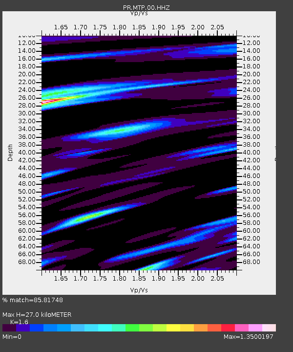
| Estimated Moho Depth: |
27.0 km |
| Estimated Crust Vp/Vs: |
1.60 |
| Assumed Crust Vp: |
5.14 km/s |
| Estimated Crust Vs: |
3.212 km/s |
| Estimated Crust Poisson's Ratio: |
0.18 |
|
| Radial Match: |
85.81748 % |
| Radial Bump: |
400 |
| Transverse Match: |
84.55319 % |
| Transverse Bump: |
400 |
| SOD ConfigId: |
25131211 |
| Insert Time: |
2021-09-05 21:38:39.497 +0000 |
| GWidth: |
2.5 |
| Max Bumps: |
400 |
| Tol: |
0.001 |
|

Signal To Noise
| Channel | StoN | STA | LTA |
| PR:MTP:00:HHZ:20210822T21:45:22.259982Z | 11.963741 | 2.187546E-6 | 1.8284798E-7 |
| PR:MTP:00:HH1:20210822T21:45:22.259982Z | 2.3773067 | 5.865739E-7 | 2.4673884E-7 |
| PR:MTP:00:HH2:20210822T21:45:22.259982Z | 2.1179335 | 3.0784608E-7 | 1.453521E-7 |
| Arrivals |
| Ps | 3.2 SECOND |
| PpPs | 13 SECOND |
| PsPs/PpSs | 17 SECOND |


