You are here: Home > Network List > WI - West Indies IPGP Network Stations List
> Station DHS Morne Mazeau - Deshaies, Guadeloupe > Earthquake Result Viewer
DHS Morne Mazeau - Deshaies, Guadeloupe - Earthquake Result Viewer
| Earthquake location: |
South Sandwich Islands Region |
| Earthquake latitude/longitude: |
-60.3/-24.9 |
| Earthquake time(UTC): |
2021/08/22 (234) 21:33:20 GMT |
| Earthquake Depth: |
14 km |
| Earthquake Magnitude: |
7.1 mww |
| Earthquake Catalog/Contributor: |
NEIC PDE/us |
|
| Network: |
WI West Indies IPGP Network |
| Station: |
DHS Morne Mazeau - Deshaies, Guadeloupe |
| Lat/Lon: |
16.27 N/61.77 W |
| Elevation: |
618 m |
|
| Distance: |
81.9 deg |
| Az: |
324.402 deg |
| Baz: |
162.429 deg |
| Ray Param: |
0.047271907 |
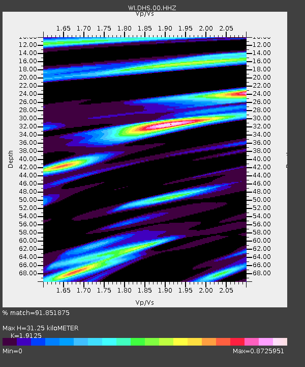
| Estimated Moho Depth: |
31.25 km |
| Estimated Crust Vp/Vs: |
1.91 |
| Assumed Crust Vp: |
6.048 km/s |
| Estimated Crust Vs: |
3.162 km/s |
| Estimated Crust Poisson's Ratio: |
0.31 |
|
| Radial Match: |
91.851875 % |
| Radial Bump: |
400 |
| Transverse Match: |
62.32804 % |
| Transverse Bump: |
400 |
| SOD ConfigId: |
25131211 |
| Insert Time: |
2021-09-05 21:40:09.243 +0000 |
| GWidth: |
2.5 |
| Max Bumps: |
400 |
| Tol: |
0.001 |
|

Signal To Noise
| Channel | StoN | STA | LTA |
| WI:DHS:00:HHZ:20210822T21:45:07.670016Z | 8.579392 | 4.1996745E-6 | 4.895072E-7 |
| WI:DHS:00:HHN:20210822T21:45:07.670016Z | 1.6321493 | 1.3164337E-6 | 8.0656446E-7 |
| WI:DHS:00:HHE:20210822T21:45:07.670016Z | 1.1831495 | 1.212328E-6 | 1.0246617E-6 |
| Arrivals |
| Ps | 4.8 SECOND |
| PpPs | 15 SECOND |
| PsPs/PpSs | 20 SECOND |


