You are here: Home > Network List > AK - Alaska Regional Network Stations List
> Station A21K Barrow, AK, USA > Earthquake Result Viewer
A21K Barrow, AK, USA - Earthquake Result Viewer
| Earthquake location: |
Kuril Islands |
| Earthquake latitude/longitude: |
48.8/155.0 |
| Earthquake time(UTC): |
2021/08/24 (236) 05:37:51 GMT |
| Earthquake Depth: |
31 km |
| Earthquake Magnitude: |
6.0 mww |
| Earthquake Catalog/Contributor: |
NEIC PDE/us |
|
| Network: |
AK Alaska Regional Network |
| Station: |
A21K Barrow, AK, USA |
| Lat/Lon: |
71.32 N/156.62 W |
| Elevation: |
5.0 m |
|
| Distance: |
31.6 deg |
| Az: |
27.383 deg |
| Baz: |
250.669 deg |
| Ray Param: |
0.07897177 |
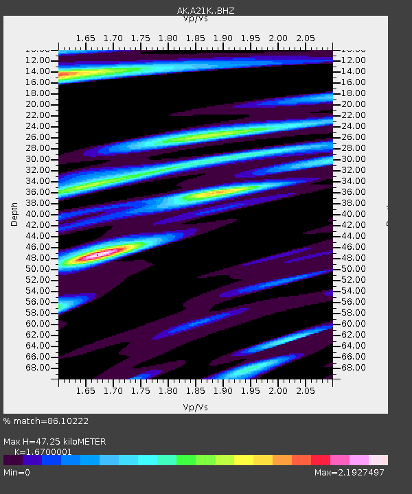
| Estimated Moho Depth: |
47.25 km |
| Estimated Crust Vp/Vs: |
1.67 |
| Assumed Crust Vp: |
6.048 km/s |
| Estimated Crust Vs: |
3.622 km/s |
| Estimated Crust Poisson's Ratio: |
0.22 |
|
| Radial Match: |
86.10222 % |
| Radial Bump: |
390 |
| Transverse Match: |
81.026436 % |
| Transverse Bump: |
400 |
| SOD ConfigId: |
25131211 |
| Insert Time: |
2021-09-07 05:39:11.898 +0000 |
| GWidth: |
2.5 |
| Max Bumps: |
400 |
| Tol: |
0.001 |
|

Signal To Noise
| Channel | StoN | STA | LTA |
| AK:A21K: :BHZ:20210824T05:43:40.799988Z | 7.7736063 | 1.5932436E-6 | 2.0495553E-7 |
| AK:A21K: :BHN:20210824T05:43:40.799988Z | 3.436509 | 6.4007764E-7 | 1.862581E-7 |
| AK:A21K: :BHE:20210824T05:43:40.799988Z | 4.9696355 | 7.275935E-7 | 1.4640783E-7 |
| Arrivals |
| Ps | 5.6 SECOND |
| PpPs | 19 SECOND |
| PsPs/PpSs | 25 SECOND |


