You are here: Home > Network List > AK - Alaska Regional Network Stations List
> Station E22K Anaktuvuk Pass, AK, USA > Earthquake Result Viewer
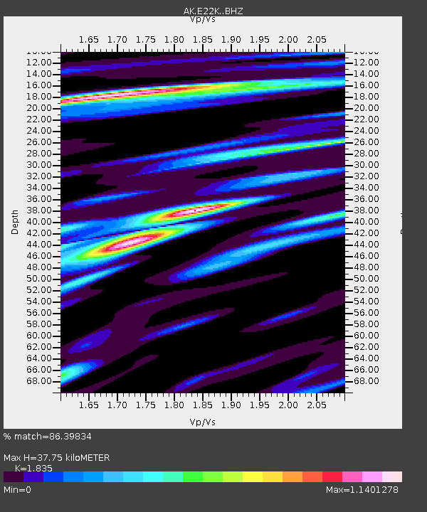
E22K Anaktuvuk Pass, AK, USA - Earthquake Result Viewer
| Earthquake location: |
Kuril Islands |
| Earthquake latitude/longitude: |
48.8/155.0 |
| Earthquake time(UTC): |
2021/08/24 (236) 05:37:51 GMT |
| Earthquake Depth: |
31 km |
| Earthquake Magnitude: |
6.0 mww |
| Earthquake Catalog/Contributor: |
NEIC PDE/us |
|
| Network: |
AK Alaska Regional Network |
| Station: |
E22K Anaktuvuk Pass, AK, USA |
| Lat/Lon: |
68.13 N/151.81 W |
| Elevation: |
772 m |
|
| Distance: |
32.4 deg |
| Az: |
34.016 deg |
| Baz: |
260.799 deg |
| Ray Param: |
0.07861856 |
| Estimated Moho Depth: |
37.75 km |
| Estimated Crust Vp/Vs: |
1.84 |
| Assumed Crust Vp: |
6.221 km/s |
| Estimated Crust Vs: |
3.39 km/s |
| Estimated Crust Poisson's Ratio: |
0.29 |
|
| Radial Match: |
86.39834 % |
| Radial Bump: |
400 |
| Transverse Match: |
71.84318 % |
| Transverse Bump: |
400 |
| SOD ConfigId: |
25131211 |
| Insert Time: |
2021-09-07 05:39:58.577 +0000 |
| GWidth: |
2.5 |
| Max Bumps: |
400 |
| Tol: |
0.001 |
|

Signal To Noise
| Channel | StoN | STA | LTA |
| AK:E22K: :BHZ:20210824T05:43:48.100006Z | 20.34078 | 1.2404237E-6 | 6.098211E-8 |
| AK:E22K: :BHN:20210824T05:43:48.100006Z | 4.7374063 | 1.9175303E-7 | 4.0476376E-8 |
| AK:E22K: :BHE:20210824T05:43:48.100006Z | 25.887867 | 6.7803387E-7 | 2.6191184E-8 |
| Arrivals |
| Ps | 5.4 SECOND |
| PpPs | 16 SECOND |
| PsPs/PpSs | 21 SECOND |


