You are here: Home > Network List > AK - Alaska Regional Network Stations List
> Station L19K White Mountain, AK, USA > Earthquake Result Viewer
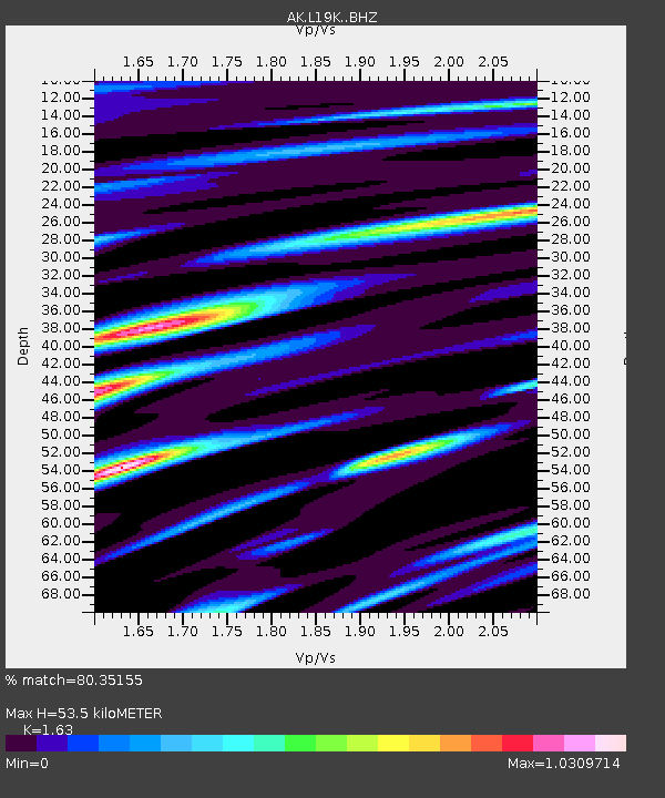
L19K White Mountain, AK, USA - Earthquake Result Viewer
| Earthquake location: |
Kuril Islands |
| Earthquake latitude/longitude: |
48.8/155.0 |
| Earthquake time(UTC): |
2021/08/24 (236) 05:37:51 GMT |
| Earthquake Depth: |
31 km |
| Earthquake Magnitude: |
6.0 mww |
| Earthquake Catalog/Contributor: |
NEIC PDE/us |
|
| Network: |
AK Alaska Regional Network |
| Station: |
L19K White Mountain, AK, USA |
| Lat/Lon: |
62.18 N/154.85 W |
| Elevation: |
650 m |
|
| Distance: |
30.5 deg |
| Az: |
45.16 deg |
| Baz: |
267.552 deg |
| Ray Param: |
0.07935491 |
| Estimated Moho Depth: |
53.5 km |
| Estimated Crust Vp/Vs: |
1.63 |
| Assumed Crust Vp: |
6.438 km/s |
| Estimated Crust Vs: |
3.95 km/s |
| Estimated Crust Poisson's Ratio: |
0.20 |
|
| Radial Match: |
80.35155 % |
| Radial Bump: |
400 |
| Transverse Match: |
63.812527 % |
| Transverse Bump: |
400 |
| SOD ConfigId: |
25131211 |
| Insert Time: |
2021-09-07 05:40:53.194 +0000 |
| GWidth: |
2.5 |
| Max Bumps: |
400 |
| Tol: |
0.001 |
|

Signal To Noise
| Channel | StoN | STA | LTA |
| AK:L19K: :BHZ:20210824T05:43:31.500Z | 4.2649193 | 6.274624E-7 | 1.4712175E-7 |
| AK:L19K: :BHN:20210824T05:43:31.500Z | 1.249905 | 1.6008089E-7 | 1.2807445E-7 |
| AK:L19K: :BHE:20210824T05:43:31.500Z | 2.163247 | 4.3375195E-7 | 2.0050966E-7 |
| Arrivals |
| Ps | 5.7 SECOND |
| PpPs | 20 SECOND |
| PsPs/PpSs | 26 SECOND |


