You are here: Home > Network List > AK - Alaska Regional Network Stations List
> Station M20K Styx River, AK, USA > Earthquake Result Viewer
M20K Styx River, AK, USA - Earthquake Result Viewer
| Earthquake location: |
Kuril Islands |
| Earthquake latitude/longitude: |
48.8/155.0 |
| Earthquake time(UTC): |
2021/08/24 (236) 05:37:51 GMT |
| Earthquake Depth: |
31 km |
| Earthquake Magnitude: |
6.0 mww |
| Earthquake Catalog/Contributor: |
NEIC PDE/us |
|
| Network: |
AK Alaska Regional Network |
| Station: |
M20K Styx River, AK, USA |
| Lat/Lon: |
61.88 N/153.13 W |
| Elevation: |
1107 m |
|
| Distance: |
31.3 deg |
| Az: |
45.783 deg |
| Baz: |
269.605 deg |
| Ray Param: |
0.07906797 |
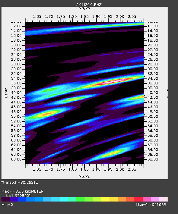
| Estimated Moho Depth: |
35.0 km |
| Estimated Crust Vp/Vs: |
1.97 |
| Assumed Crust Vp: |
6.566 km/s |
| Estimated Crust Vs: |
3.329 km/s |
| Estimated Crust Poisson's Ratio: |
0.33 |
|
| Radial Match: |
80.26211 % |
| Radial Bump: |
400 |
| Transverse Match: |
54.089428 % |
| Transverse Bump: |
400 |
| SOD ConfigId: |
25131211 |
| Insert Time: |
2021-09-07 05:41:01.654 +0000 |
| GWidth: |
2.5 |
| Max Bumps: |
400 |
| Tol: |
0.001 |
|

Signal To Noise
| Channel | StoN | STA | LTA |
| AK:M20K: :BHZ:20210824T05:43:38.559998Z | 4.4511647 | 7.2726186E-7 | 1.6338687E-7 |
| AK:M20K: :BHN:20210824T05:43:38.559998Z | 1.2381968 | 2.2268642E-7 | 1.7984735E-7 |
| AK:M20K: :BHE:20210824T05:43:38.559998Z | 3.634784 | 5.429755E-7 | 1.4938315E-7 |
| Arrivals |
| Ps | 5.6 SECOND |
| PpPs | 15 SECOND |
| PsPs/PpSs | 20 SECOND |


