You are here: Home > Network List > TA - USArray Transportable Network (new EarthScope stations) Stations List
> Station TUL3 Leonard, OK, USA > Earthquake Result Viewer
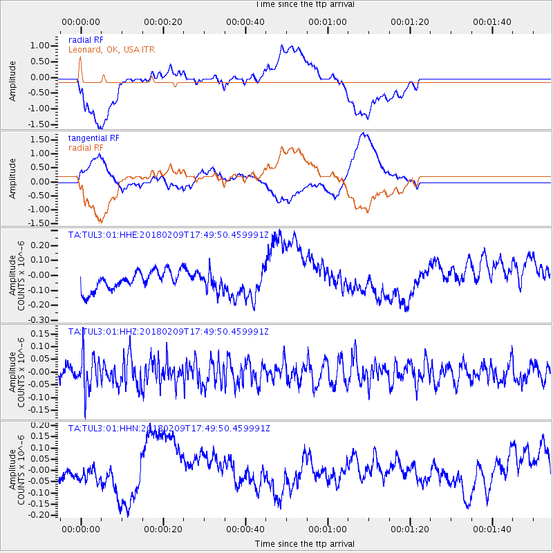
TUL3 Leonard, OK, USA - Earthquake Result Viewer
*The percent match for this event was below the threshold and hence no stack was calculated.
| Earthquake location: |
Leeward Islands |
| Earthquake latitude/longitude: |
19.0/-61.7 |
| Earthquake time(UTC): |
2018/02/09 (040) 17:43:34 GMT |
| Earthquake Depth: |
9.9 km |
| Earthquake Magnitude: |
5.5 Mi |
| Earthquake Catalog/Contributor: |
NEIC PDE/pt |
|
| Network: |
TA USArray Transportable Network (new EarthScope stations) |
| Station: |
TUL3 Leonard, OK, USA |
| Lat/Lon: |
35.91 N/95.79 W |
| Elevation: |
265 m |
|
| Distance: |
34.4 deg |
| Az: |
306.424 deg |
| Baz: |
110.271 deg |
| Ray Param: |
$rayparam |
*The percent match for this event was below the threshold and hence was not used in the summary stack. |
|
| Radial Match: |
49.35847 % |
| Radial Bump: |
400 |
| Transverse Match: |
36.49217 % |
| Transverse Bump: |
400 |
| SOD ConfigId: |
2546091 |
| Insert Time: |
2018-02-23 17:45:48.697 +0000 |
| GWidth: |
2.5 |
| Max Bumps: |
400 |
| Tol: |
0.001 |
|
Signal To Noise
| Channel | StoN | STA | LTA |
| TA:TUL3:01:HHZ:20180209T17:49:50.459991Z | 3.1460912 | 6.938711E-8 | 2.2055023E-8 |
| TA:TUL3:01:HHN:20180209T17:49:50.459991Z | 0.5928076 | 3.8097912E-8 | 6.426691E-8 |
| TA:TUL3:01:HHE:20180209T17:49:50.459991Z | 0.98674 | 6.1286684E-8 | 6.211026E-8 |
| Arrivals |
| Ps | |
| PpPs | |
| PsPs/PpSs | |


