You are here: Home > Network List > AV - Alaska Volcano Observatory Stations List
> Station SPCR Ckakachatna River, Mount Spurr, Alaska > Earthquake Result Viewer
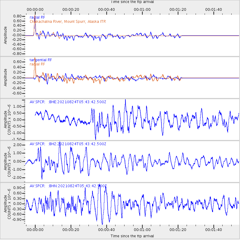
SPCR Ckakachatna River, Mount Spurr, Alaska - Earthquake Result Viewer
*The percent match for this event was below the threshold and hence no stack was calculated.
| Earthquake location: |
Kuril Islands |
| Earthquake latitude/longitude: |
48.8/155.0 |
| Earthquake time(UTC): |
2021/08/24 (236) 05:37:51 GMT |
| Earthquake Depth: |
31 km |
| Earthquake Magnitude: |
6.0 mww |
| Earthquake Catalog/Contributor: |
NEIC PDE/us |
|
| Network: |
AV Alaska Volcano Observatory |
| Station: |
SPCR Ckakachatna River, Mount Spurr, Alaska |
| Lat/Lon: |
61.20 N/152.21 W |
| Elevation: |
984 m |
|
| Distance: |
31.8 deg |
| Az: |
47.082 deg |
| Baz: |
271.522 deg |
| Ray Param: |
$rayparam |
*The percent match for this event was below the threshold and hence was not used in the summary stack. |
|
| Radial Match: |
65.945984 % |
| Radial Bump: |
400 |
| Transverse Match: |
64.616165 % |
| Transverse Bump: |
400 |
| SOD ConfigId: |
25131211 |
| Insert Time: |
2021-09-07 05:43:25.853 +0000 |
| GWidth: |
2.5 |
| Max Bumps: |
400 |
| Tol: |
0.001 |
|
Signal To Noise
| Channel | StoN | STA | LTA |
| AV:SPCR: :BHZ:20210824T05:43:42.500Z | 4.9302626 | 9.737917E-7 | 1.9751313E-7 |
| AV:SPCR: :BHN:20210824T05:43:42.500Z | 1.5585377 | 2.737814E-7 | 1.7566556E-7 |
| AV:SPCR: :BHE:20210824T05:43:42.500Z | 2.3165822 | 6.454998E-7 | 2.7864317E-7 |
| Arrivals |
| Ps | |
| PpPs | |
| PsPs/PpSs | |


