You are here: Home > Network List > C8 - Canadian Seismic Research Network () Stations List
> Station KITB Kitimat, BC, CA > Earthquake Result Viewer
KITB Kitimat, BC, CA - Earthquake Result Viewer
| Earthquake location: |
Kuril Islands |
| Earthquake latitude/longitude: |
48.8/155.0 |
| Earthquake time(UTC): |
2021/08/24 (236) 05:37:51 GMT |
| Earthquake Depth: |
31 km |
| Earthquake Magnitude: |
6.0 mww |
| Earthquake Catalog/Contributor: |
NEIC PDE/us |
|
| Network: |
C8 Canadian Seismic Research Network () |
| Station: |
KITB Kitimat, BC, CA |
| Lat/Lon: |
54.08 N/128.64 W |
| Elevation: |
72 m |
|
| Distance: |
45.7 deg |
| Az: |
53.095 deg |
| Baz: |
296.238 deg |
| Ray Param: |
0.0710245 |
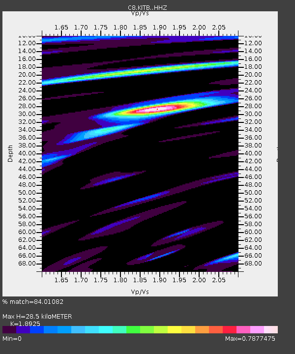
| Estimated Moho Depth: |
28.5 km |
| Estimated Crust Vp/Vs: |
1.89 |
| Assumed Crust Vp: |
6.438 km/s |
| Estimated Crust Vs: |
3.402 km/s |
| Estimated Crust Poisson's Ratio: |
0.31 |
|
| Radial Match: |
84.01082 % |
| Radial Bump: |
400 |
| Transverse Match: |
85.495384 % |
| Transverse Bump: |
400 |
| SOD ConfigId: |
25131211 |
| Insert Time: |
2021-09-07 05:44:51.201 +0000 |
| GWidth: |
2.5 |
| Max Bumps: |
400 |
| Tol: |
0.001 |
|
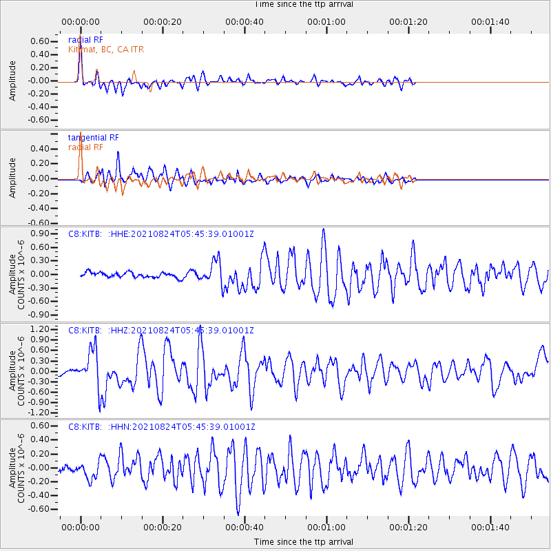
Signal To Noise
| Channel | StoN | STA | LTA |
| C8:KITB: :HHZ:20210824T05:45:39.01001Z | 9.543803 | 5.483512E-7 | 5.745625E-8 |
| C8:KITB: :HHN:20210824T05:45:39.01001Z | 2.0994358 | 1.2652004E-7 | 6.026383E-8 |
| C8:KITB: :HHE:20210824T05:45:39.01001Z | 4.734668 | 2.6358163E-7 | 5.5670565E-8 |
| Arrivals |
| Ps | 4.2 SECOND |
| PpPs | 12 SECOND |
| PsPs/PpSs | 16 SECOND |


