You are here: Home > Network List > IM - International Miscellaneous Stations Stations List
> Station NV31 NVAR Array, Mina, NV, USA > Earthquake Result Viewer
NV31 NVAR Array, Mina, NV, USA - Earthquake Result Viewer
| Earthquake location: |
Nicaragua |
| Earthquake latitude/longitude: |
11.2/-85.5 |
| Earthquake time(UTC): |
2005/08/03 (215) 11:03:15 GMT |
| Earthquake Depth: |
14 km |
| Earthquake Magnitude: |
6.0 MB, 6.5 MS, 6.3 MW, 6.3 MW |
| Earthquake Catalog/Contributor: |
WHDF/NEIC |
|
| Network: |
IM International Miscellaneous Stations |
| Station: |
NV31 NVAR Array, Mina, NV, USA |
| Lat/Lon: |
38.43 N/118.15 W |
| Elevation: |
1585 m |
|
| Distance: |
39.7 deg |
| Az: |
318.541 deg |
| Baz: |
124.203 deg |
| Ray Param: |
0.07479965 |
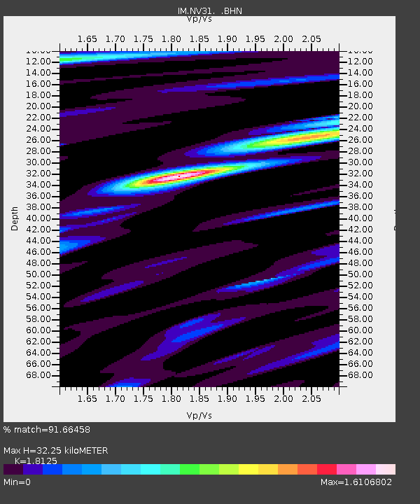
| Estimated Moho Depth: |
32.25 km |
| Estimated Crust Vp/Vs: |
1.81 |
| Assumed Crust Vp: |
6.279 km/s |
| Estimated Crust Vs: |
3.464 km/s |
| Estimated Crust Poisson's Ratio: |
0.28 |
|
| Radial Match: |
91.66458 % |
| Radial Bump: |
400 |
| Transverse Match: |
88.433174 % |
| Transverse Bump: |
400 |
| SOD ConfigId: |
2475 |
| Insert Time: |
2010-03-09 11:55:20.029 +0000 |
| GWidth: |
2.5 |
| Max Bumps: |
400 |
| Tol: |
0.001 |
|

Signal To Noise
| Channel | StoN | STA | LTA |
| IM:NV31: :BHN:20050803T11:10:16.300013Z | 3.0774152 | 3.2622291E-4 | 1.06005486E-4 |
| IM:NV31: :BHE:20050803T11:10:16.300013Z | 2.9800394 | 7.117834E-4 | 2.3885033E-4 |
| IM:NV31: :BHZ:20050803T11:10:16.300013Z | 3.5130045 | 8.50179E-4 | 2.4200908E-4 |
| Arrivals |
| Ps | 4.5 SECOND |
| PpPs | 14 SECOND |
| PsPs/PpSs | 18 SECOND |


