You are here: Home > Network List > IM - International Miscellaneous Stations Stations List
> Station NV31 NVAR Array, Mina, NV, USA > Earthquake Result Viewer
NV31 NVAR Array, Mina, NV, USA - Earthquake Result Viewer
| Earthquake location: |
Northern Peru |
| Earthquake latitude/longitude: |
-5.7/-76.4 |
| Earthquake time(UTC): |
2005/09/26 (269) 01:55:37 GMT |
| Earthquake Depth: |
115 km |
| Earthquake Magnitude: |
6.7 MB, 7.5 MW, 7.5 MW |
| Earthquake Catalog/Contributor: |
WHDF/NEIC |
|
| Network: |
IM International Miscellaneous Stations |
| Station: |
NV31 NVAR Array, Mina, NV, USA |
| Lat/Lon: |
38.43 N/118.15 W |
| Elevation: |
1585 m |
|
| Distance: |
58.5 deg |
| Az: |
322.173 deg |
| Baz: |
129.005 deg |
| Ray Param: |
0.062448423 |
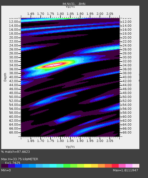
| Estimated Moho Depth: |
33.75 km |
| Estimated Crust Vp/Vs: |
1.76 |
| Assumed Crust Vp: |
6.279 km/s |
| Estimated Crust Vs: |
3.562 km/s |
| Estimated Crust Poisson's Ratio: |
0.26 |
|
| Radial Match: |
97.6623 % |
| Radial Bump: |
400 |
| Transverse Match: |
92.00535 % |
| Transverse Bump: |
400 |
| SOD ConfigId: |
2475 |
| Insert Time: |
2010-03-09 11:55:24.858 +0000 |
| GWidth: |
2.5 |
| Max Bumps: |
400 |
| Tol: |
0.001 |
|

Signal To Noise
| Channel | StoN | STA | LTA |
| IM:NV31: :BHN:20050926T02:04:51.300005Z | 31.19577 | 0.007853003 | 2.5173297E-4 |
| IM:NV31: :BHE:20050926T02:04:51.300005Z | 24.863352 | 0.011429462 | 4.5969113E-4 |
| IM:NV31: :BHZ:20050926T02:04:51.300005Z | 86.150314 | 0.029941166 | 3.4754563E-4 |
| Arrivals |
| Ps | 4.3 SECOND |
| PpPs | 14 SECOND |
| PsPs/PpSs | 18 SECOND |


