You are here: Home > Network List > CN - Canadian National Seismograph Network Stations List
> Station KILO Kirkland Lake, ON, CA > Earthquake Result Viewer
KILO Kirkland Lake, ON, CA - Earthquake Result Viewer
| Earthquake location: |
Kuril Islands |
| Earthquake latitude/longitude: |
48.8/155.0 |
| Earthquake time(UTC): |
2021/08/24 (236) 05:37:51 GMT |
| Earthquake Depth: |
31 km |
| Earthquake Magnitude: |
6.0 mww |
| Earthquake Catalog/Contributor: |
NEIC PDE/us |
|
| Network: |
CN Canadian National Seismograph Network |
| Station: |
KILO Kirkland Lake, ON, CA |
| Lat/Lon: |
48.50 N/79.72 W |
| Elevation: |
314 m |
|
| Distance: |
72.2 deg |
| Az: |
34.756 deg |
| Baz: |
325.492 deg |
| Ray Param: |
0.053796884 |
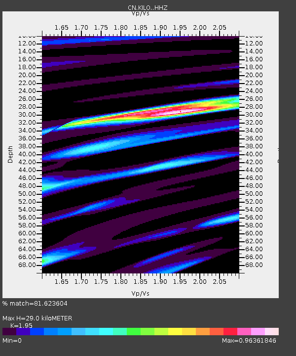
| Estimated Moho Depth: |
29.0 km |
| Estimated Crust Vp/Vs: |
1.95 |
| Assumed Crust Vp: |
6.61 km/s |
| Estimated Crust Vs: |
3.39 km/s |
| Estimated Crust Poisson's Ratio: |
0.32 |
|
| Radial Match: |
81.623604 % |
| Radial Bump: |
351 |
| Transverse Match: |
59.975876 % |
| Transverse Bump: |
400 |
| SOD ConfigId: |
25131211 |
| Insert Time: |
2021-09-07 05:49:37.320 +0000 |
| GWidth: |
2.5 |
| Max Bumps: |
400 |
| Tol: |
0.001 |
|

Signal To Noise
| Channel | StoN | STA | LTA |
| CN:KILO: :HHZ:20210824T05:48:41.920014Z | 5.6735415 | 8.9290717E-7 | 1.5738091E-7 |
| CN:KILO: :HHN:20210824T05:48:41.920014Z | 2.2056754 | 2.3729356E-7 | 1.07583176E-7 |
| CN:KILO: :HHE:20210824T05:48:41.920014Z | 1.9375149 | 1.9812482E-7 | 1.0225719E-7 |
| Arrivals |
| Ps | 4.3 SECOND |
| PpPs | 13 SECOND |
| PsPs/PpSs | 17 SECOND |


