You are here: Home > Network List > CN - Canadian National Seismograph Network Stations List
> Station WHY Whitehorse, YT, CA > Earthquake Result Viewer
WHY Whitehorse, YT, CA - Earthquake Result Viewer

| Earthquake location: |
Kuril Islands |
| Earthquake latitude/longitude: |
48.8/155.0 |
| Earthquake time(UTC): |
2021/08/24 (236) 05:37:51 GMT |
| Earthquake Depth: |
31 km |
| Earthquake Magnitude: |
6.0 mww |
| Earthquake Catalog/Contributor: |
NEIC PDE/us |
|
| Network: |
CN Canadian National Seismograph Network |
| Station: |
WHY Whitehorse, YT, CA |
| Lat/Lon: |
60.66 N/134.88 W |
| Elevation: |
1273 m |
|
| Distance: |
40.2 deg |
| Az: |
45.842 deg |
| Baz: |
285.663 deg |
| Ray Param: |
0.074470766 |
| Estimated Moho Depth: |
22.75 km |
| Estimated Crust Vp/Vs: |
1.80 |
| Assumed Crust Vp: |
6.419 km/s |
| Estimated Crust Vs: |
3.571 km/s |
| Estimated Crust Poisson's Ratio: |
0.28 |
|
| Radial Match: |
92.85534 % |
| Radial Bump: |
400 |
| Transverse Match: |
86.72885 % |
| Transverse Bump: |
400 |
| SOD ConfigId: |
25131211 |
| Insert Time: |
2021-09-07 05:50:53.765 +0000 |
| GWidth: |
2.5 |
| Max Bumps: |
400 |
| Tol: |
0.001 |
|
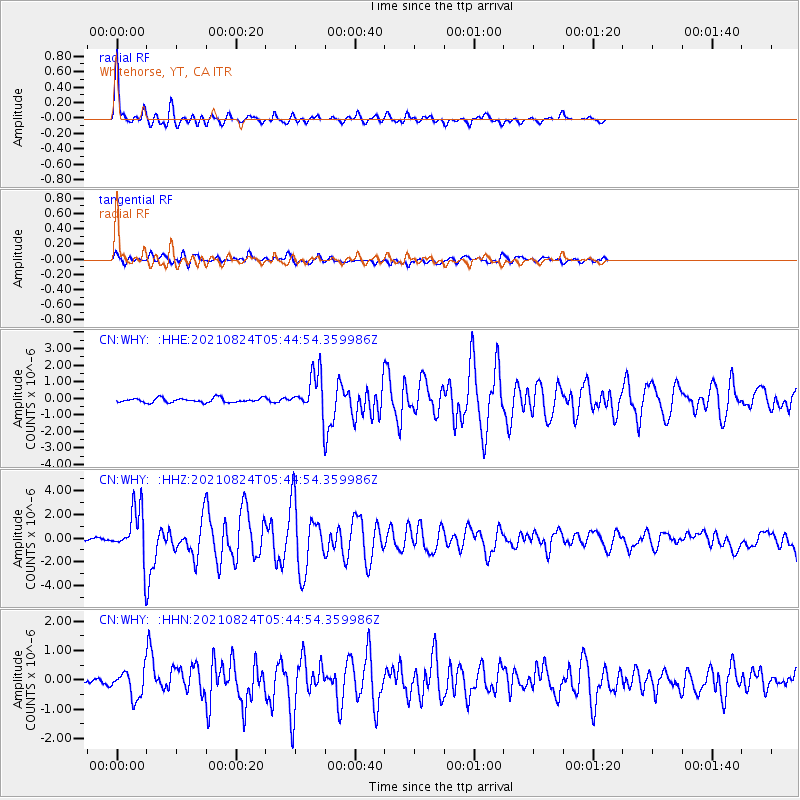
Signal To Noise
| Channel | StoN | STA | LTA |
| CN:WHY: :HHZ:20210824T05:44:54.359986Z | 18.293627 | 2.0562834E-6 | 1.1240435E-7 |
| CN:WHY: :HHN:20210824T05:44:54.359986Z | 3.6932375 | 4.484721E-7 | 1.214306E-7 |
| CN:WHY: :HHE:20210824T05:44:54.359986Z | 8.835737 | 1.176976E-6 | 1.332063E-7 |
| Arrivals |
| Ps | 3.0 SECOND |
| PpPs | 9.3 SECOND |
| PsPs/PpSs | 12 SECOND |


