You are here: Home > Network List > GS - US Geological Survey Networks Stations List
> Station ASA4 ASA4 > Earthquake Result Viewer
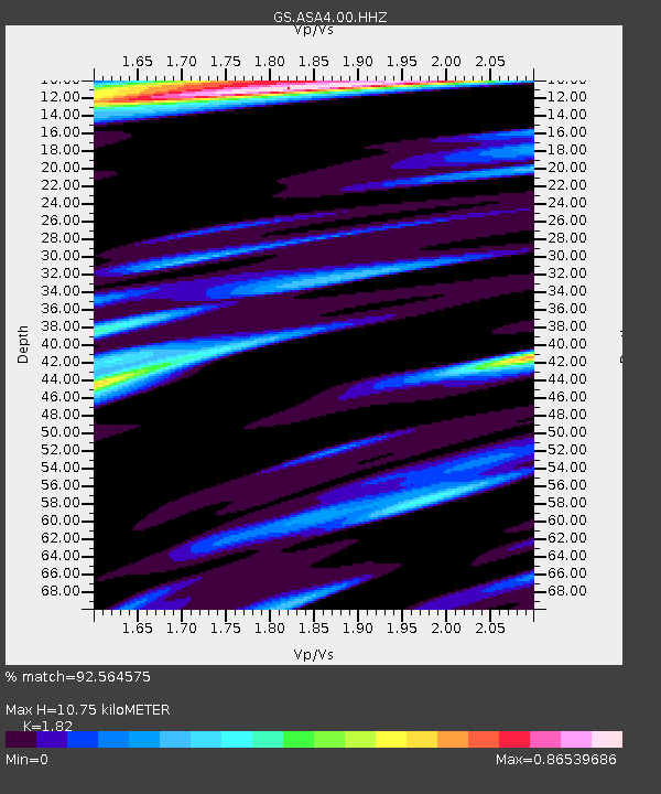
ASA4 ASA4 - Earthquake Result Viewer
| Earthquake location: |
Kuril Islands |
| Earthquake latitude/longitude: |
48.8/155.0 |
| Earthquake time(UTC): |
2021/08/24 (236) 05:37:51 GMT |
| Earthquake Depth: |
31 km |
| Earthquake Magnitude: |
6.0 mww |
| Earthquake Catalog/Contributor: |
NEIC PDE/us |
|
| Network: |
GS US Geological Survey Networks |
| Station: |
ASA4 ASA4 |
| Lat/Lon: |
34.94 N/106.46 W |
| Elevation: |
1820 m |
|
| Distance: |
69.7 deg |
| Az: |
60.007 deg |
| Baz: |
315.826 deg |
| Ray Param: |
0.055422977 |
| Estimated Moho Depth: |
10.75 km |
| Estimated Crust Vp/Vs: |
1.82 |
| Assumed Crust Vp: |
6.502 km/s |
| Estimated Crust Vs: |
3.572 km/s |
| Estimated Crust Poisson's Ratio: |
0.28 |
|
| Radial Match: |
92.564575 % |
| Radial Bump: |
400 |
| Transverse Match: |
66.96449 % |
| Transverse Bump: |
400 |
| SOD ConfigId: |
25131211 |
| Insert Time: |
2021-09-07 05:53:28.748 +0000 |
| GWidth: |
2.5 |
| Max Bumps: |
400 |
| Tol: |
0.001 |
|

Signal To Noise
| Channel | StoN | STA | LTA |
| GS:ASA4:00:HHZ:20210824T05:48:26.99997Z | 7.1100116 | 5.0008407E-7 | 7.03352E-8 |
| GS:ASA4:00:HH1:20210824T05:48:26.99997Z | 4.642796 | 1.7370067E-7 | 3.7412946E-8 |
| GS:ASA4:00:HH2:20210824T05:48:26.99997Z | 3.2796903 | 1.8884194E-7 | 5.75792E-8 |
| Arrivals |
| Ps | 1.4 SECOND |
| PpPs | 4.5 SECOND |
| PsPs/PpSs | 5.9 SECOND |


