You are here: Home > Network List > GS - US Geological Survey Networks Stations List
> Station DEC04 Decatur Surface Seismic Site, Decatur, IL, USA > Earthquake Result Viewer
DEC04 Decatur Surface Seismic Site, Decatur, IL, USA - Earthquake Result Viewer
| Earthquake location: |
Kuril Islands |
| Earthquake latitude/longitude: |
48.8/155.0 |
| Earthquake time(UTC): |
2021/08/24 (236) 05:37:51 GMT |
| Earthquake Depth: |
31 km |
| Earthquake Magnitude: |
6.0 mww |
| Earthquake Catalog/Contributor: |
NEIC PDE/us |
|
| Network: |
GS US Geological Survey Networks |
| Station: |
DEC04 Decatur Surface Seismic Site, Decatur, IL, USA |
| Lat/Lon: |
39.88 N/88.86 W |
| Elevation: |
225 m |
|
| Distance: |
75.2 deg |
| Az: |
45.571 deg |
| Baz: |
322.164 deg |
| Ray Param: |
0.051762253 |
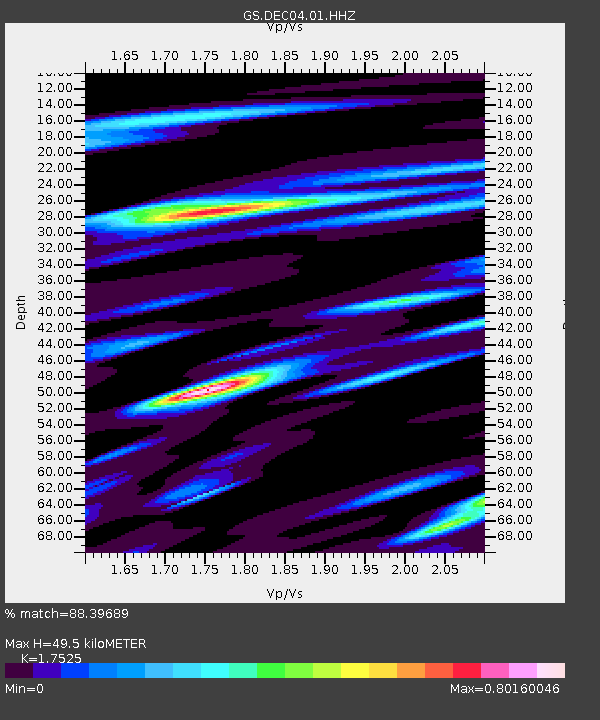
| Estimated Moho Depth: |
49.5 km |
| Estimated Crust Vp/Vs: |
1.75 |
| Assumed Crust Vp: |
6.444 km/s |
| Estimated Crust Vs: |
3.677 km/s |
| Estimated Crust Poisson's Ratio: |
0.26 |
|
| Radial Match: |
88.39689 % |
| Radial Bump: |
400 |
| Transverse Match: |
32.940445 % |
| Transverse Bump: |
400 |
| SOD ConfigId: |
25131211 |
| Insert Time: |
2021-09-07 05:53:35.434 +0000 |
| GWidth: |
2.5 |
| Max Bumps: |
400 |
| Tol: |
0.001 |
|

Signal To Noise
| Channel | StoN | STA | LTA |
| GS:DEC04:01:HHZ:20210824T05:48:59.855011Z | 7.203581 | 1.2156056E-6 | 1.6875019E-7 |
| GS:DEC04:01:HHN:20210824T05:48:59.855011Z | 2.1268327 | 7.411251E-7 | 3.4846425E-7 |
| GS:DEC04:01:HHE:20210824T05:48:59.855011Z | 1.6791623 | 4.68845E-7 | 2.7921365E-7 |
| Arrivals |
| Ps | 6.0 SECOND |
| PpPs | 20 SECOND |
| PsPs/PpSs | 26 SECOND |


