You are here: Home > Network List > US - United States National Seismic Network Stations List
> Station NEW Newport, Washington, USA > Earthquake Result Viewer
NEW Newport, Washington, USA - Earthquake Result Viewer
*The percent match for this event was below the threshold and hence no stack was calculated.
| Earthquake location: |
Leeward Islands |
| Earthquake latitude/longitude: |
19.0/-61.7 |
| Earthquake time(UTC): |
2018/02/09 (040) 17:43:34 GMT |
| Earthquake Depth: |
9.9 km |
| Earthquake Magnitude: |
5.5 Mi |
| Earthquake Catalog/Contributor: |
NEIC PDE/pt |
|
| Network: |
US United States National Seismic Network |
| Station: |
NEW Newport, Washington, USA |
| Lat/Lon: |
48.26 N/117.12 W |
| Elevation: |
760 m |
|
| Distance: |
53.2 deg |
| Az: |
316.601 deg |
| Baz: |
103.311 deg |
| Ray Param: |
$rayparam |
*The percent match for this event was below the threshold and hence was not used in the summary stack. |
|
| Radial Match: |
36.135845 % |
| Radial Bump: |
400 |
| Transverse Match: |
55.012325 % |
| Transverse Bump: |
400 |
| SOD ConfigId: |
2546091 |
| Insert Time: |
2018-02-23 17:47:15.833 +0000 |
| GWidth: |
2.5 |
| Max Bumps: |
400 |
| Tol: |
0.001 |
|
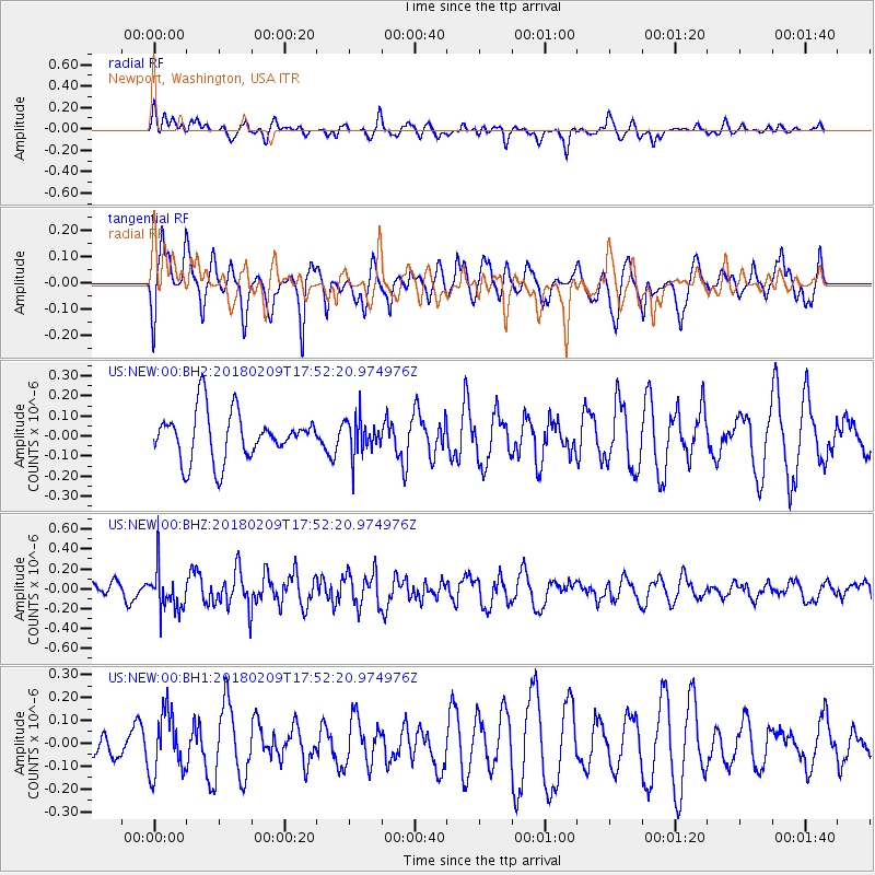
Signal To Noise
| Channel | StoN | STA | LTA |
| US:NEW:00:BHZ:20180209T17:52:20.974976Z | 2.7691689 | 2.1551871E-7 | 7.782794E-8 |
| US:NEW:00:BH1:20180209T17:52:20.974976Z | 1.5962607 | 1.3213338E-7 | 8.277682E-8 |
| US:NEW:00:BH2:20180209T17:52:20.974976Z | 0.7675644 | 9.076262E-8 | 1.1824756E-7 |
| Arrivals |
| Ps | |
| PpPs | |
| PsPs/PpSs | |


